Several years ago, I was flying a drone – a DJI Inspire 2 – when the battery failed while the drone was around 300 feet and over water. A death spiral ensued and with a meek splash, as I watched in disbelief, the little flying contraption hit the water and sank quietly to the bottom of the Colorado River near Pennybacker Bridge. After experiencing the worst customer service imaginable (DJI wouldn’t honor any warranty that was caused by a battery failure despite the data showing it was not user error, just an orginal faulty battery that came with the drone), I gave up on drones for several years.
Last January changed things. I decided to once again add aerial photography to my portfolio, so I spent a few weeks studying for the FAA Part 107 exam, a test that allows one to fly a drone and sell the work commercially. On a cold day in San Marcos, I sat at a computer for less than 30 minutes, scored a 95 on the test, and was on my way. I thought the test was shockingly easy, but I had also spent time preparing, so maybe the studying paid off.
I should state here rather emphatically I don’t want to be one of those guys with a drone that annoy folks or bends the rules. I’m very careful not to interfere with someone’s peace nor invade their privacy. I usually fly straight up and straight down unless I’m over water, and and probably overly cautious. Anyway, I digress…
I waited another ten months until I finally purchased a drone. I bit the bullet and bought another DJI unit – this time a Mavic Pro 2 – and what sold me was the Hasselblad camera that was part of the drone. For my business, I need to be able to print fairly large prints. While not huge, I’ve been able to produce detailed prints at 54” wide, and the panoramas stitched from several images have been printed up to 9 feet wide.
While flying, I take no risks, and I take a ton of shots. I’ve found that some photos will come back with just a bit of blur – nothing that would be noticeable in smaller prints, but for enlargements, I need sharp, crisp originals.
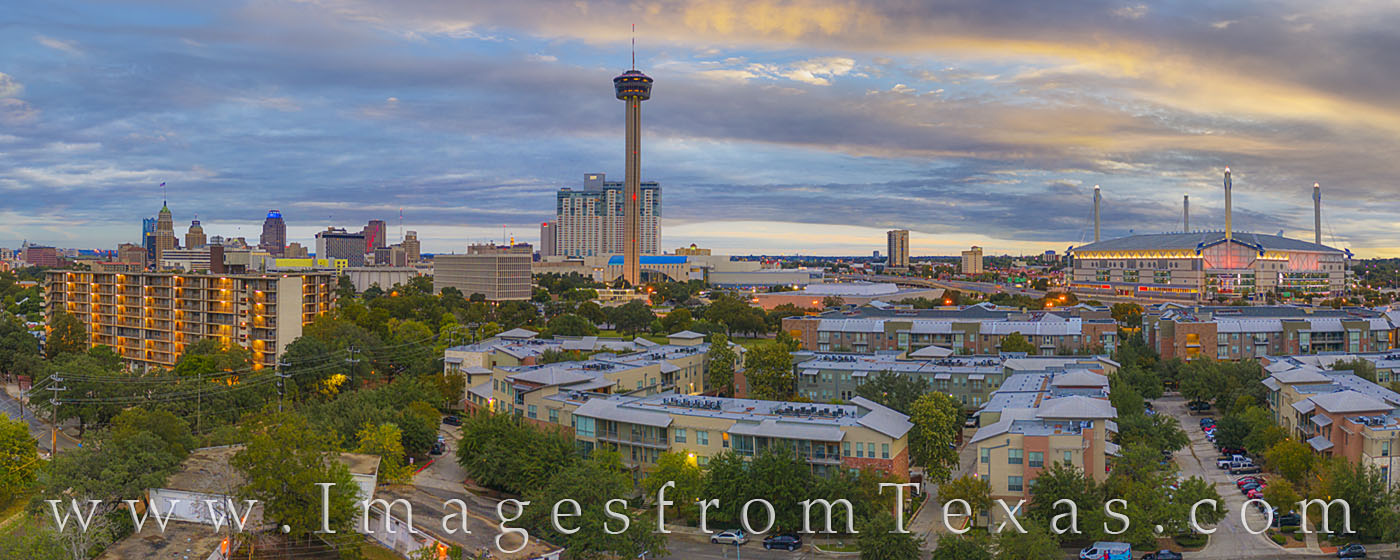
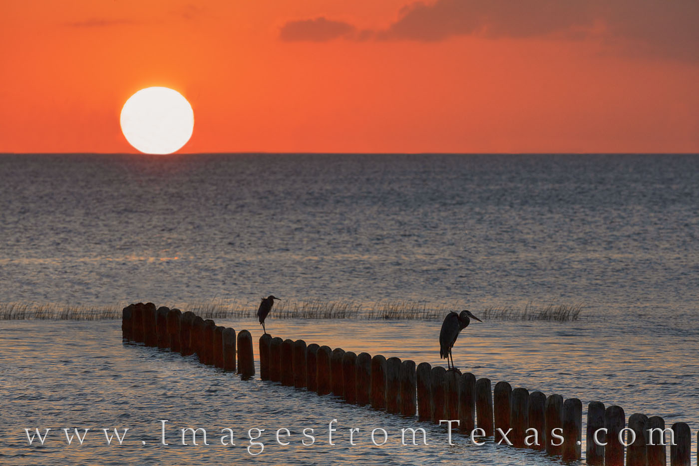
After several test flights and practicing with the camera settings and gimbal, I was able to take a few trips to put the new drone in use. A few shots from San Antonio under windy conditions produced this panorama showing the well-known Tower of the Americas and Alamodome. San Antonio Skyline – November Sunrise 1 : Prints Available
From southwest San Antonio, this view of the skyline shows the Tower of the Americas prominently. to the east (right) is the Alamodome. to the left (west, is the main skyline. In the distance, even the new Frost Tower, similar to the Frost Tower in Austin, is peeking out from behind the Tower of Life building.
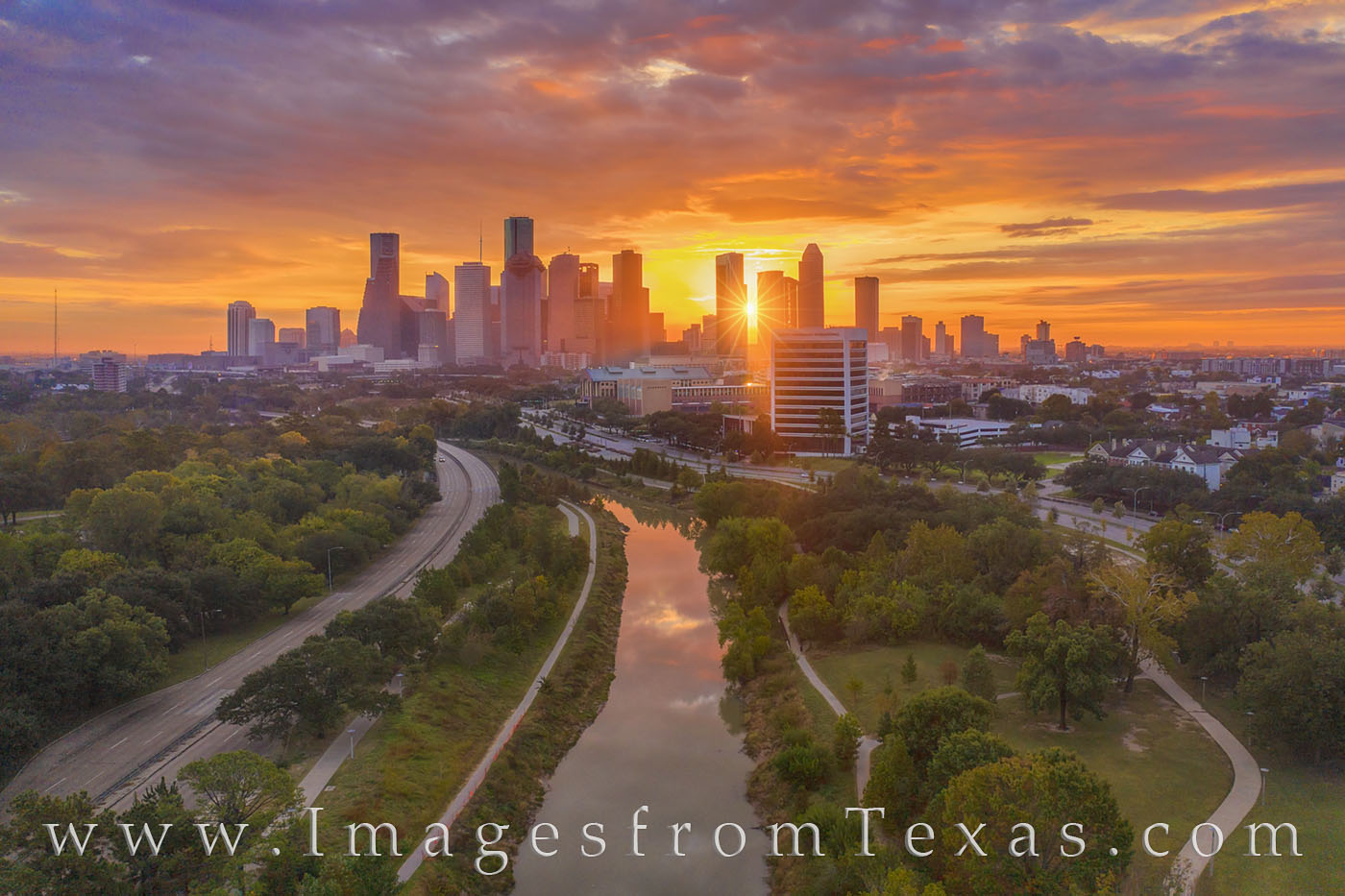
The next weekend, my family and I headed to Houston to shoot the skyline around Buffalo Bayou along Allen Parkway. Here are a few images taken near sunset and at sunrise on a perfect 24 hours just before storms rolled into Texas’ largest city: Houston Skyline Panorama November Afternoon 1 : Prints Available
A lazy Saturday afternoon finds blue skies over the Houston skyline on a cool day in November. Below, Buffalo Bayou finds folks outdoors biking, jogging, or just taking a stoll along the paths lining the water between Allen Pkwy and Memorial Parkway. This image was taken with a drone. I am a Licensed FAA Part 107 pilot.
From high over Buffalo Bayou on a beautiful November morning, the sun breaks through the clouds and shines the first light of day through the highrises of the Houston skyline. Far below, Buffalo Bayou flows along, flanked by Memorial Parkway and Allen Parkway. The tallest building in the skyline is the JP Morgan Chase Tower at 1,002 feet high. This aerial sunrise image was taken with a drone and a licensed FAA Part 107 pilot (me).
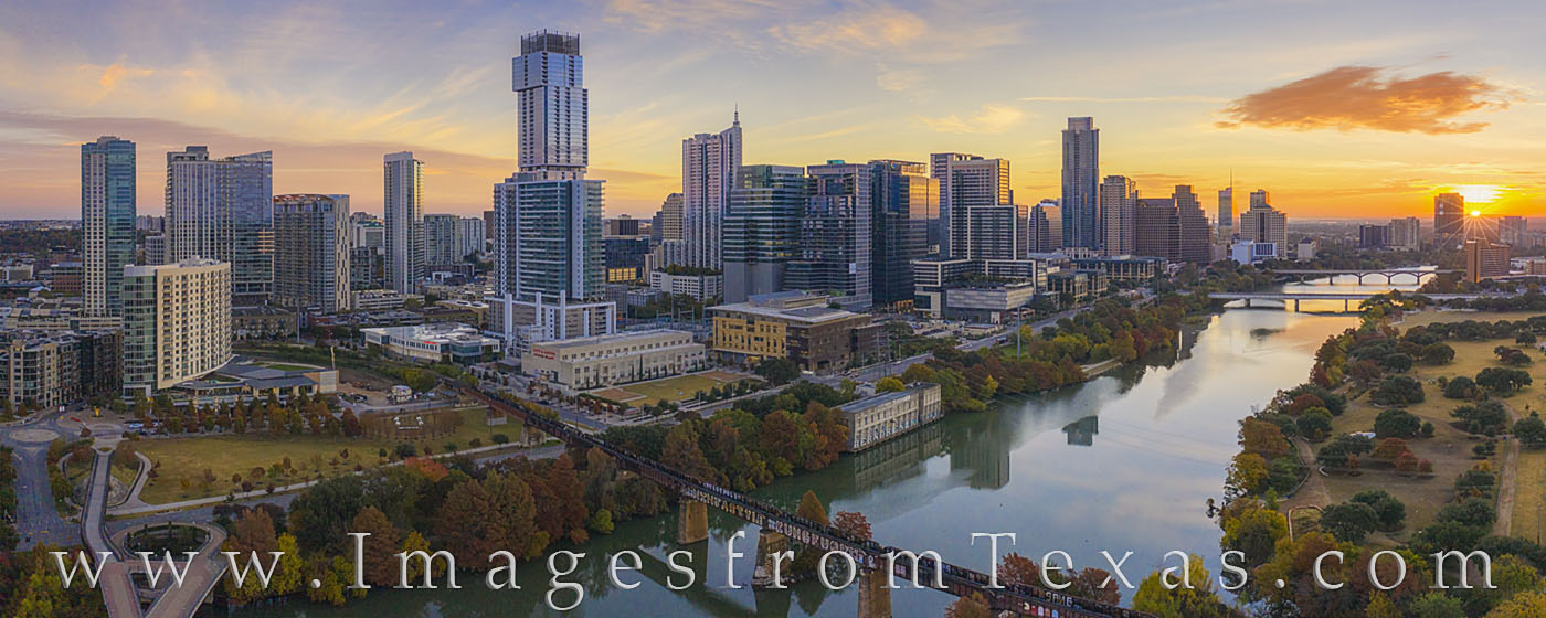
The first sunlight peeks over the horizon and downtown Austin, Texas. This aerial panorama was taken with a drone and looks down on Ladybird Lake and across to the highrises of the capitol city. Taken in late November, the Autumn colors along the water are just showing up in the morning light.
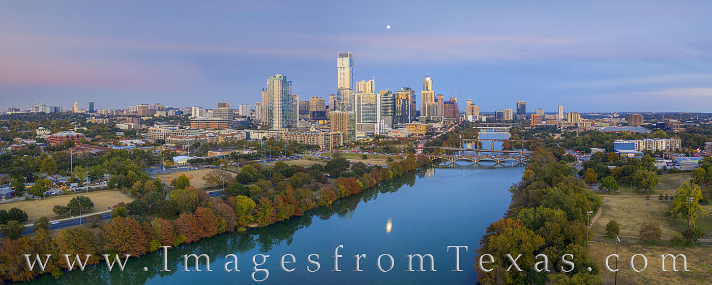
On a beautiful November evening, this aerial photograph of downtown Austin and the skyline shows shows the fall colors found along Ladybird Lake. The “Jenga Tower” (formally known as the Independent) tops out at 685’ and is the tallest highrise in Austin, narrowly eclipsing the Austonian (683’).
Overall, I’m liking the Mavic Pro 2. I’m not into the technical aspects, so you can get that information elsewhere, but I will say this little flying machine is fun to fly, easy and intuitive, and with a little post processing, can produce nice images that folks seem to like. And for me, that is the bottom line. I look forward to adding to my gallery featuring aerial photographs from across Texas.
Thanks for listening. If you have any questions, please don’t hesitate to shoot me an email.
The alarm goes off. It is 4am. Rain is falling outside and I’m nice and dry inside my sleeping bag – inside my old 4-Runner 30 miles from Presidio, Texas, in Big Bend Ranch State Park.
I had made the 8.5 hour trek to this location for two main reasons – to photograph the landscape from the highest point in the park – Oso Peak – and to make a return trip to Fresno Canyon to photograph sunrise.
But is is 4am and raining. I’m not sure I want to crawl from my warm bag and drive 20 minutes down a dirt road to the trailhead. But I do, and soon I’m bumping through the dark while trying to munch down a protein bar and sip from my small bottle of Sweat Leaf peach tea. How many people would really do this? How many people have even heard of Fresno Canyon and the Solitario?
Rain is still falling as I reach the trailhead. I put on a headlamp, calibrate the GPS, double check the tripod, camera, and lenses, gatorade, and snacks I’m bringing along, and with a flashlight in hand and headlamp on, head into the dark.
I’m torn… the clouds above show patches of light and dark, but the rain is still gently falling. This trek is all about faith.That’s a pretty good analogy. I’ll have to remember that.
I press on. The trail is relatively faint, but sporadically marked by cairns. It is an easy hike – some might even call it a walk. Every once in a while I have to turn on my hand-held flashlight and search for the next pile of rocks. This is my second attempt to reach the rim of Fresno Canyon. Last year, I lost the trail in the dark and missed sunrise at the canyom rim by about a quarter mile. I won’t make that mistake again.
The rains have mostly stopped. The air is cool and I’m still in complete darkness. Stars are visible to the west and even overhead.
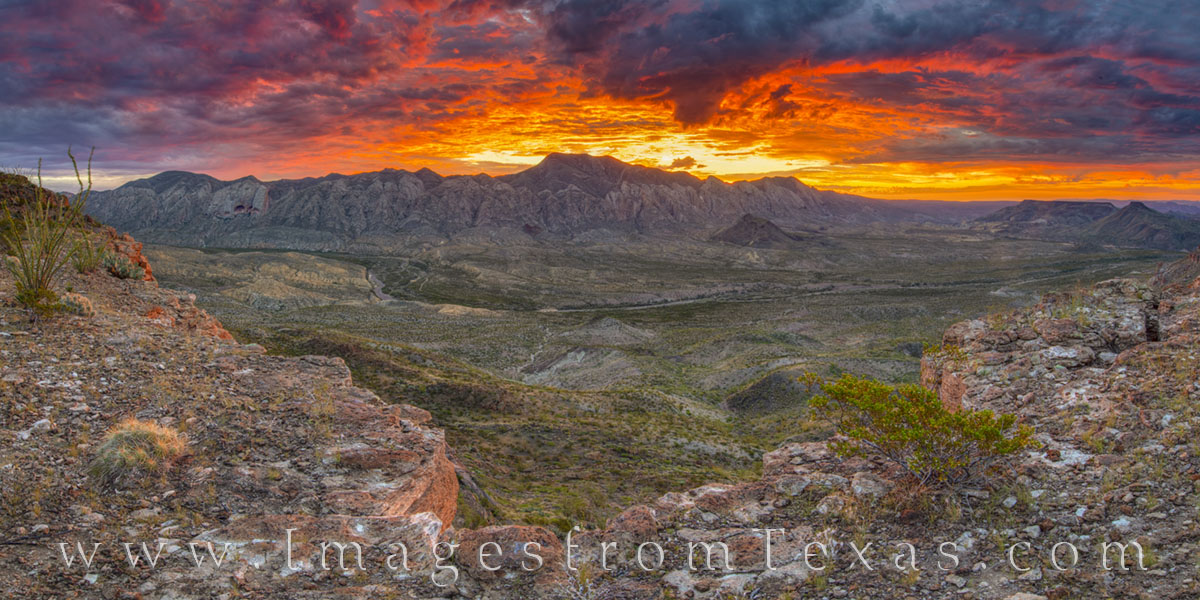
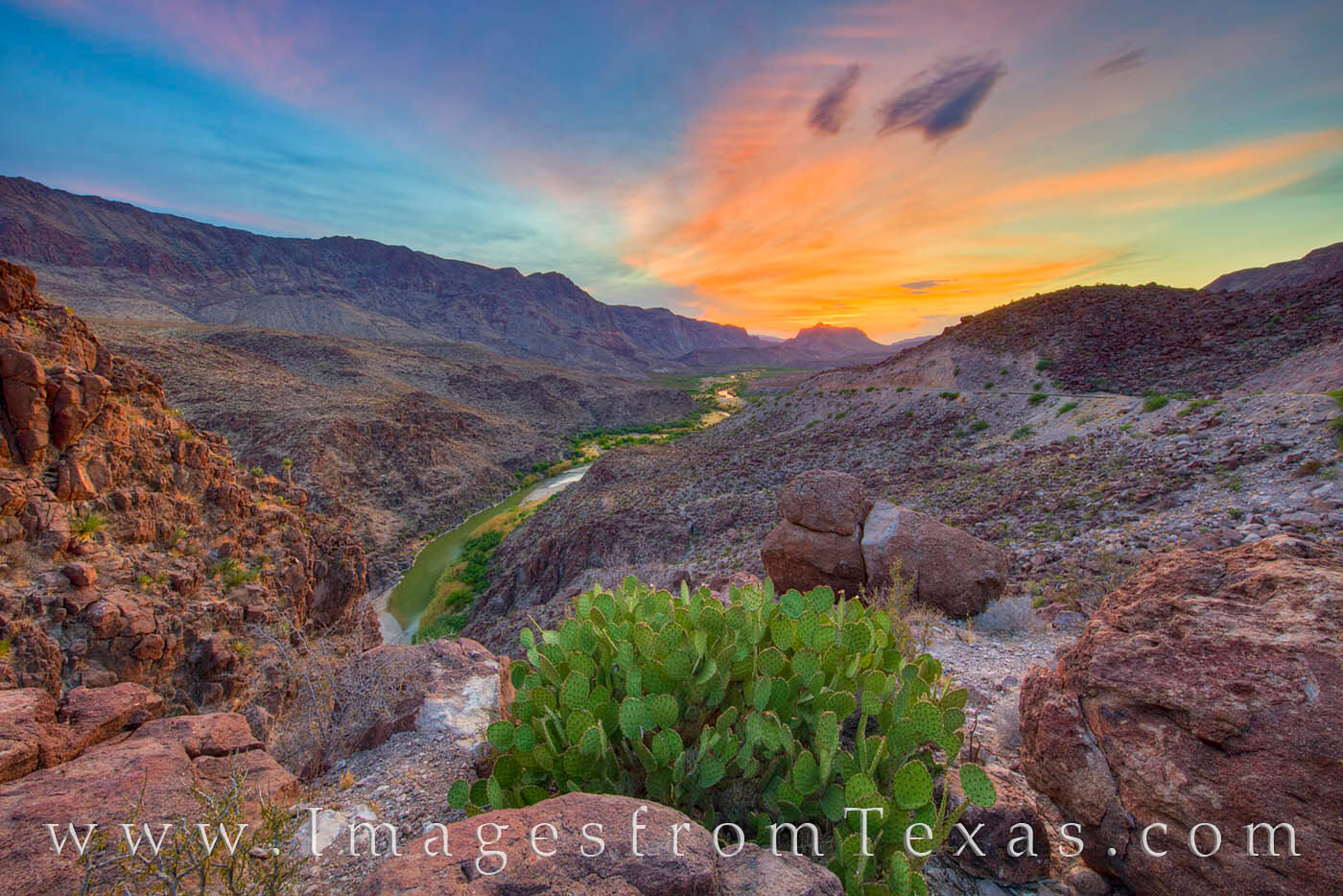
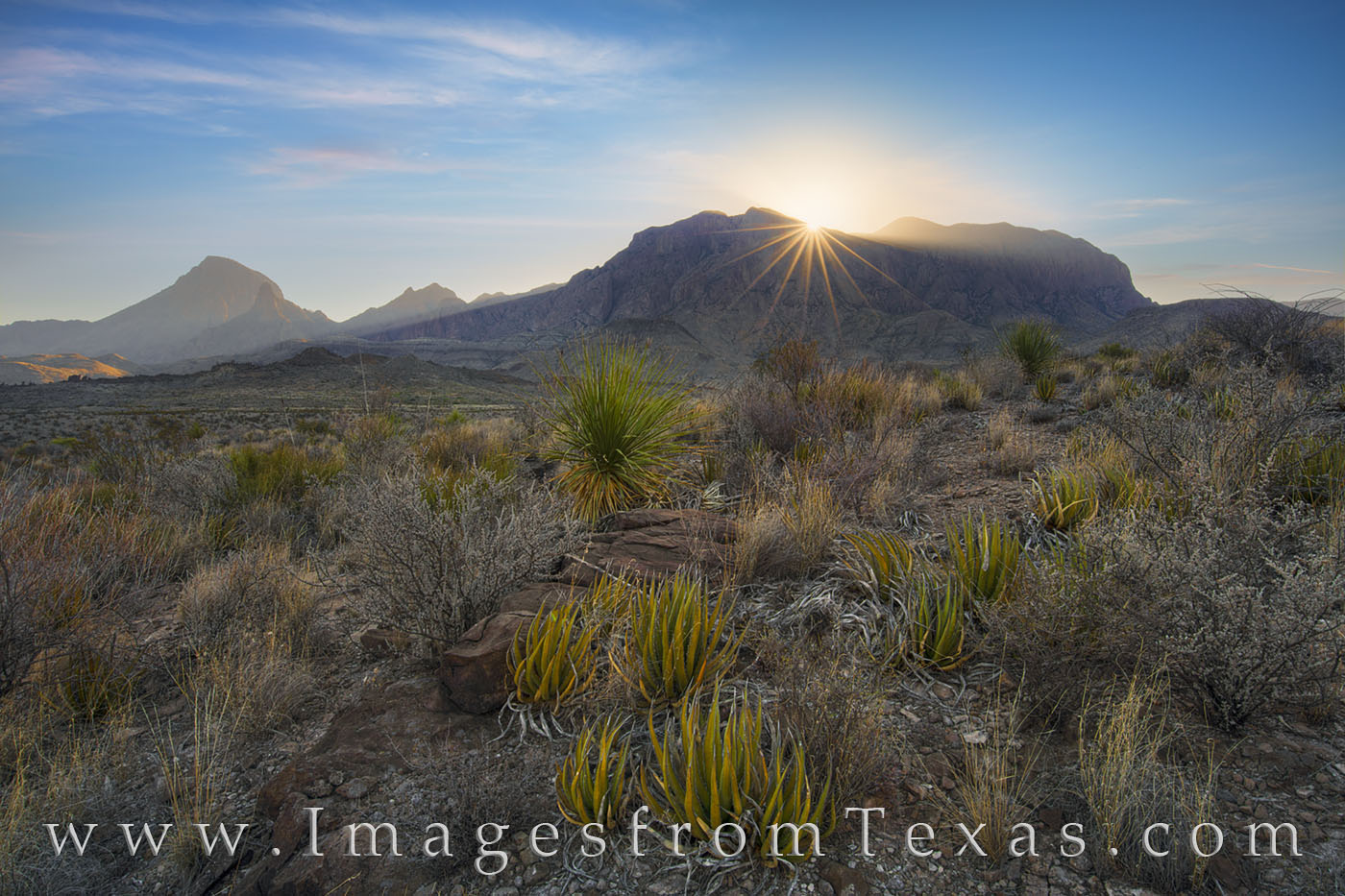
After two miles of easy walking, I reach the edge of a large wash. A switchbacking trail leads down into the small valley, into some dense vegetation. Hopefully, no bears or mountain lions are hanging around. In ten seconds, I’m heading back up the trail to the top of the wash. Five more minutes of walking and I can see the faint outline of the Solitario, a circular rock formation that covers over 50 miles. The complex geologic structure rises from the Chihuahuan Desert and is flanked on its west side by Fresno Canyon.
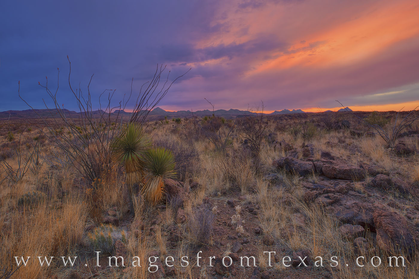
I know I have arrived. With dark skies overhead, I see traces of light along the ridges of the Solitario. Slowly, I step the edge of the canyon rim and peer into the abyss. Still surrounded in darkness, I’m left to wonder what it will look like when daylight arrives. Splashes of red and orange begin to outline the clouds above the distant rock cliffs. This has a lot of potential.
The next 30 minutes are a blur. The sky catches fire in one of the most stunning sunrises I’ve ever experienced. The canyon seems to echo in full vibrant color. The grace and the beauty of this desolate and rugged land arise like a vast fire for a few fleeting minutes. The Solitario Sunrise Panorama 106-1 : Prints Available
This panorama shows Fresno Canyon and the Solitario in Big Bend Ranch State Park. My morning to reach this amazing sight began at 4am. I was sleeping in the back of my 4Runner because of the overnight rains. When I awoke, the rains were still falling. Nevertheless, I organized my pack, drove the few miles down a relatively easy 4WD road, and started the hike around 5am. The rains were lighter, and I could even see a few stars in the west. Two and a half miles later, after an easy walk through the desert, though route-finding was a bit difficult in the dark, I found myself standing on the edge of Fresno Canyon. Few Texans have seen Fresno Canyon, and many folks don’t even know if its existence. I felt priveleged to stand there. Across the gorge, the Solitario rose from the floor. From overhead, the uplift appears like an impact zone, but it actually the remains of a laccolith (an uplift of igneous rock in a circular shape) and covers approximately 52 square miles. As light began to spread through an opening between the horizon and clouds, the sky overhead slowly turned to fire, glowing in reds, oranges, and golds. This sunrise was one of the most amazing sights I’ve had the opportunity to both experience and photograph. I hope this image in some small way conveys the beauty of that rare morning.
This is a lesson for me… Sometimes I just have to keep moving – hoping it will all be worth it – because sometimes it is. I’m glad I kept walking – even in the rain.
Vaya con Dios, my friends.
~ Rob
www.ImagesfromTexas.com
www.facebook.com/ImagesfromTexas
After almost a week in the wilds of Big Bend Ranch State Park, then over to Big Bend National Park, I found myself exploring an area of Texas I didn’t know quite as well – Brownsville, Texas. I’d walked the sands of South Padre Island and driven the Queen Isabella Causeway in the past, but I’ve not photographed the resacas (waterways) in this border town. I had the opportunity to basically be guided around the area by a local, and jumped at the chance.
My friend – I’ll call him Mark for now – is a photographer, as well, and better than he gives himself credit. We met in San Antonio just after lunch and made the drive to Brownsville. Mark had written down 25 potential locations for me to shoot, locations in Brownsville, Port Isabel, and South Padre Island. He’d made arrangements for us to stay in Brownsville, so that first night we focused on a few scenic resacas.
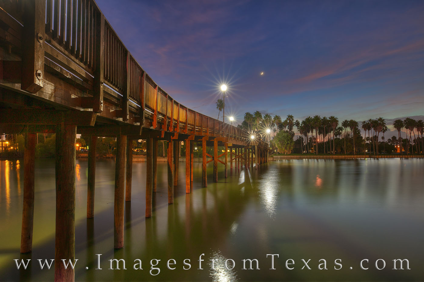
Before the trip, I had never heard the word resaca. Now I know these waterways are remnants of the Rio Grande River flow. Ten percent of Brownsville is taken by these waterways, and with the sun low in the horizon followed by a setting crescent moon, the evening offered some nice photographic opportunities. Bridge over a Resaca in Evening, Brownsville 1 : Prints Available
A crescent moon sets in the west over a resaca in Brownsville, Texas. These waterways are found throughout this border town and add beauty to the city. This footbridge crosses the water on the campus of Texas Southmost College.
That first night, I noticed traffic seemed a little haphazard. In some ways, it reminded me of my younger days when commuting in Rome. I once had been driven around the eternal city by a monsignor at the Vatican (he was an American serving there). I asked him what was his secret to managing the driving madness. His answer: Don’t make eye contact! He said if your eyes met the eyes of another driver, that gave him permission to cut you off. I asked if he’d ever been in any wrecks. His answer, grinning: Sure, everyone who drives here has. Brownsville wasn’t that bad. As we weaved in and out of traffic on a Thursday night in Brownsville, I asked Mark if it was always so crazy driving here. Smiling, he said: It’s Brownsville. I’m glad to say we never had any fender-benders, but driving was a bit sketchy at times.
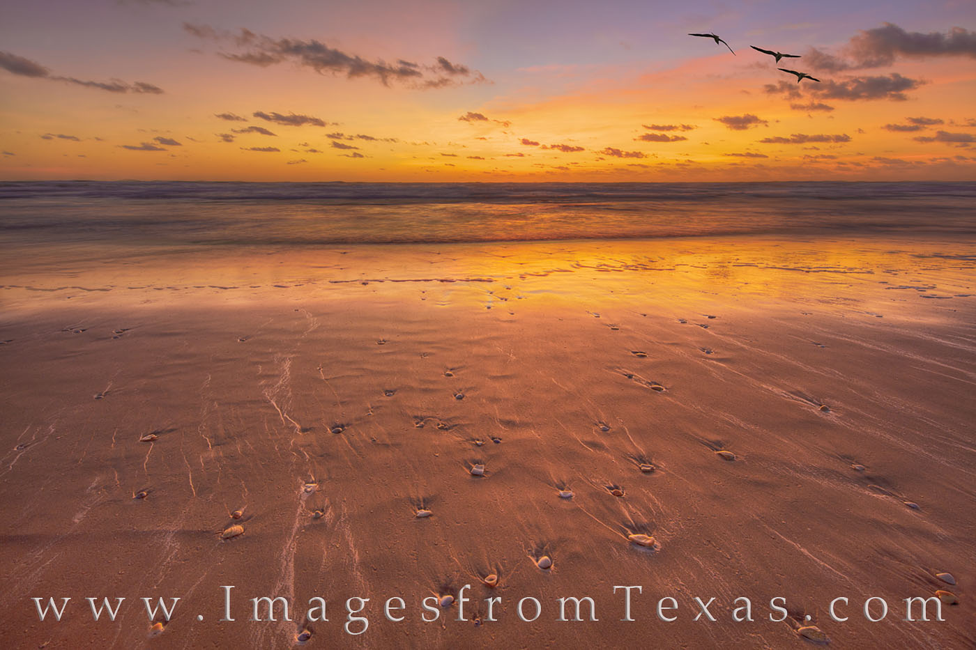
We awoke on Saturday morning well before dark. Our destination this a.m. was past Port Isabel and over the bay (Laguna Madre) to the sand dunes of South Padre Island. We had planned on driving down Ocean Blvd until we found some nice dunes, but high water prevented us from traveling more than a few miles before the road was too much under water for us to continue. I had no idea that a hurricane 600 miles away could affect the water levels on the beach. But it had. So we parked, scampered up and over the sand to the east, then dropped down the other side and headed toward the ocean. From there, on a windy October morning, we both enjoyed a beautiful sunrise. The beach was filled with shells and parts of shells. When the water would recede between waves, the shells would leave zig-zagged and curving lines in the sand. With the sun’s glow on the sand, I really liked the lines in the beach.South Padre Island Seashells in Surf 1 : Prints Available
From South Padre Island, this is a beautiful early morning sunrise. As the waves washed out to the Gulf waters, the lines in the sand created by shells tumbling in the shifting surf weave a tapestry in the orange light of morning. Overhead, three gulls watched my work from overhead.
We played here, photographing every angle we could manage, then headed to the other side of the island to photograph any fowl we might find. After that, a trip over the causeway to Port Isabel allowed us a brief stop to photograph the Lighthouse in the center of town. After that, I was guided to an amazing Mexican restaurant, but not before shooting the courthouse of Cameron County.
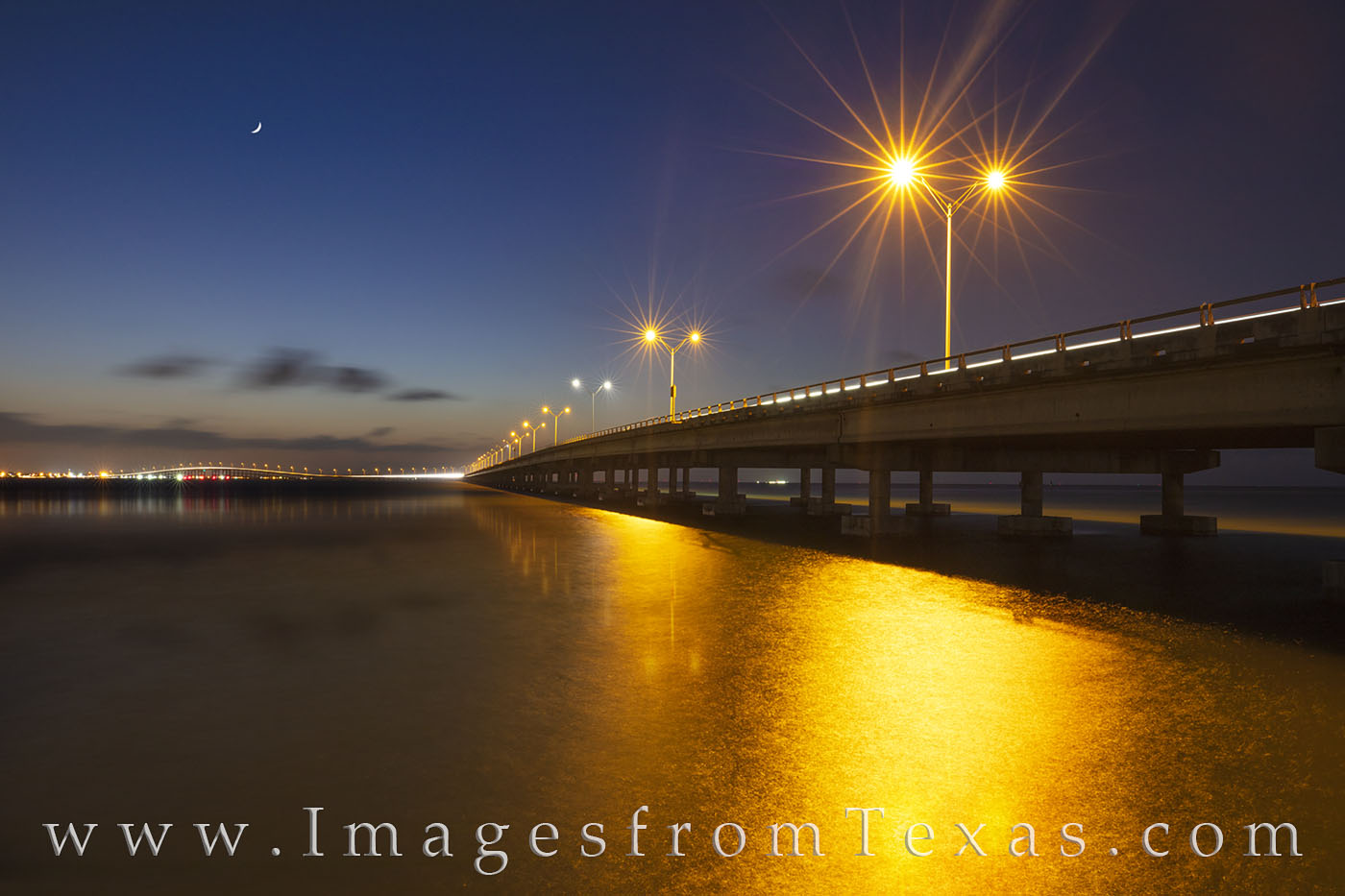
After a midday siesta, Mark took me back to the island,but this time we were shopping for stuffed dolphins. Yes, being away from my family sometimes requires me to bring my girls a gift as pennance for being gone. And they love dolphins. After stopping at several tacky tourists shops, I finally found a pink and a blue dolphin – perfect for a peace offering. From the tacky tourist are, we shot several locations – birds on a stump in the water at sunset using a 400mm prime lens, the east side of the Queen Isabella Causeway, and the west side of the Causeway. Queen Isabella Causeway from South Padre 1 : Prints Available
The Queen Isabella Causeway stretches 2.37 miles from Port Isabel to South Padre Island. It spans the Laguna Madre and is the onlyl road connecting the south Texas mainland with the island. This image was taken from the South Padre Island as a crescent moon was setting in the west.
On a humid October evening on South Padre Island just north of Port Isabel, the sun last light spreads across the water between the Island and the mainland. In the foreground, an egret searches for fish who may swim his way.
We tried to photograph some shrimp boats, but in asking for permission from (apparently) the crew, the gnarly guys working did not speak English. I tried talking slower and louder and using hand gestures, but one fellow just took a drag from his one-inch cigarette, turned, and walked away. The other said, I think, we needed to talk to the boss. When asked where the boss was, he shrugged and sat back down to do whatever was doing before being interrupted.
That night, after a long, hot, and humid day, Mark took me to a street taco dive. Both outside and in, the area was teeming with Hispanic folks enjoying the evening. I am 100% sure we were the only gringos in the place. And the street tacos – bisteak and barbacoa with avocado and goat cheese were amazing. I tried the sauces, too. The orange sauce, whatever that was, left the right side of my face numb – as if I’d been to see the dentist. Some might ask if I was a true Texan. The answer is yes – 4th generation! And that stuff was numbingly hot. The left side of my face will remember how good those tacos tasted. The right side remembers nothing.
A little more time in Brownsville shooting around Texas Southmost College and the resacas made it a successful, fun, and enlightening trip. I had some great food, donated some blood to the local mosquitoes around the water, and enjoyed exploring a new location.
My lingering thoughts on Brownsville and the coast…
– the people I met were truly friendly and kind
– the food was amazing – lunch, street tacos, and a bakery we found the final morning about 6am
– the mosquito population is alive and well
– Brownsville has some surprisingly gorgeous areas
– I’m still finding sand from a windy morning on the beach
– It is a long drive from the Hill Country to the Texas/Mexico border.
If you’ve been following my work, you probably know my business keeps me busy photographing great landscapes and even some skylines across our great state. But each summer for the last 20+ years, I’ve spent a few months in Colorado with a home base in Winter Park. Last year, because my Texas photography business was going so well, and since I had a plethora of Colorado images, I decided to branch out to Colorado. With my kids in school, it is harder for me to trek to the mountains in the non-summer months, but I’ve been trying. But for now, summers are my time to roam, explore, and shoot. This past June and July have been no exception. So in this blog I wanted to share some of the highlights from outside of Texas.
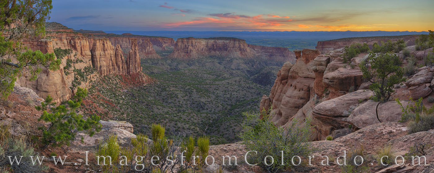
First, I spent about a week total shooting a place that reminded me very much of west Texas and one of my favorite places, Big Bend National Park. Colorado National Monument is just west of Grand Junction. It is a hidden gem and not very visited by tourists, but the canyons are mesmerizing, especially in the morning and evening light. Rim Rock Road runs along the rim of several canyons, offering access to amazing hiking trails and beautiful vistas. Monument Canyon stretches out as a grand landscape of the western slope. Colorado National Monument is a gem just west of Grand Junction – and not as well known as it should be. Rim Rock Road runs 22 miles through these canyons through this portion of the Colorado Plateau, providing amazing views of several cliffs and rock rock monoliths. This panorama was taken just before sunrise on a peaceful summer morning.
This Colorado panorama is available in custom and larger sizes.
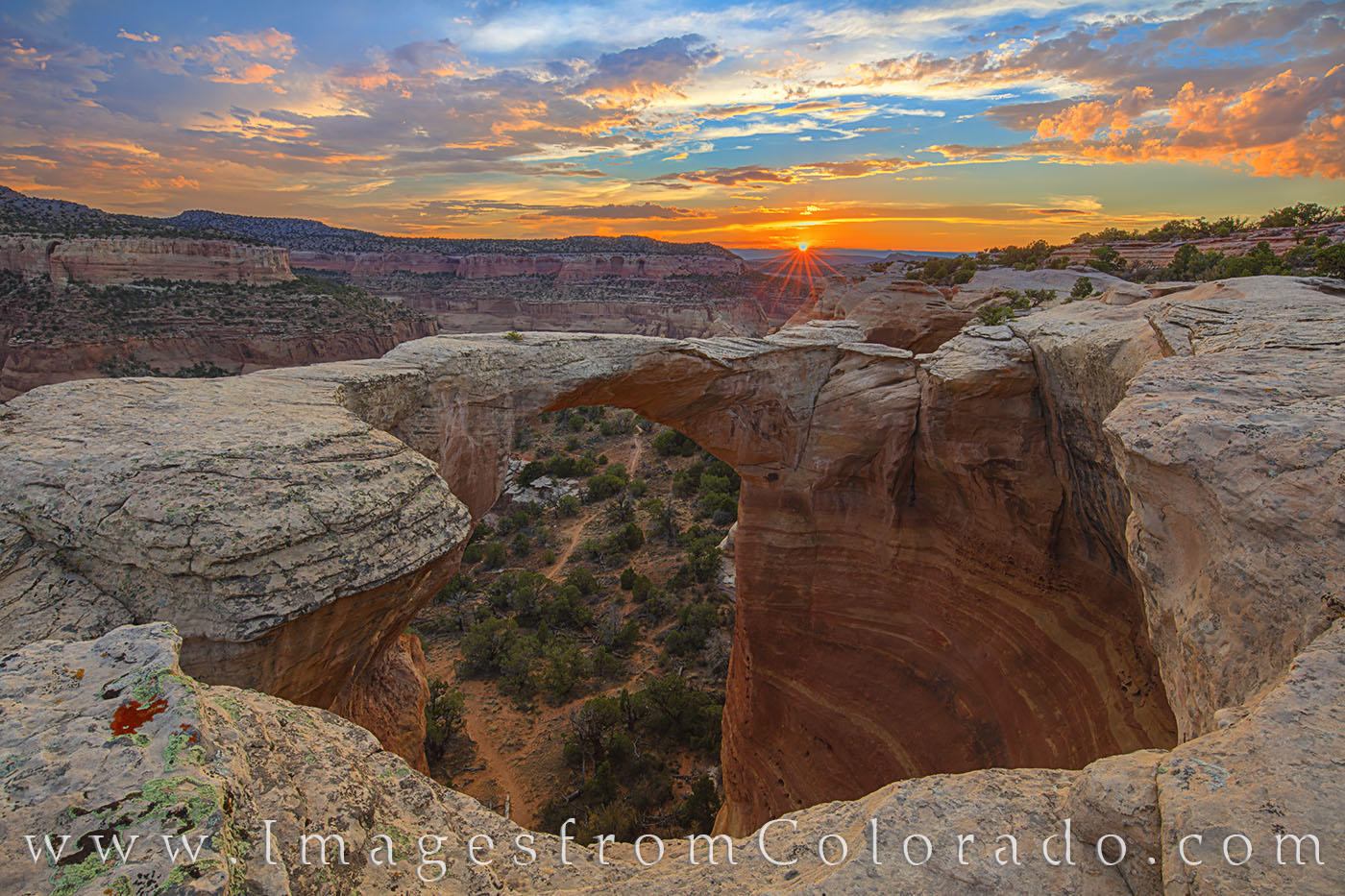
Further west, with Black Ridge Road connecting the two, McInnis Canyons, and especially Rattlesnake Canyon and Arches, are just a few miles away. The catch is, to access the arches requires a heavy-duty 4WD, high clearance vehicle. Fortunately, I have a friend and a Grand Junction native offer his services, so we drove approximately 8 miles in about an hour over absolutely terrible roads to shoot at the Rattlesnake Arches for a sunset and sunrise. The light was spectacular and provided both images and memories that will last a long time. From iconic Rattlesnake Arch in Rattlesnake Canyon, the evening sky lights up at the end of a July day. This beautiful area is found in the McInnis Canyons National Conservation Area. While this is open to the public, access is difficult, requiring either a rugged 4WD truck or a 15 mile round trip hike. But the views at sunrise and sunset of this canyon landscape are unparalleled and quite distinct in Colorado.
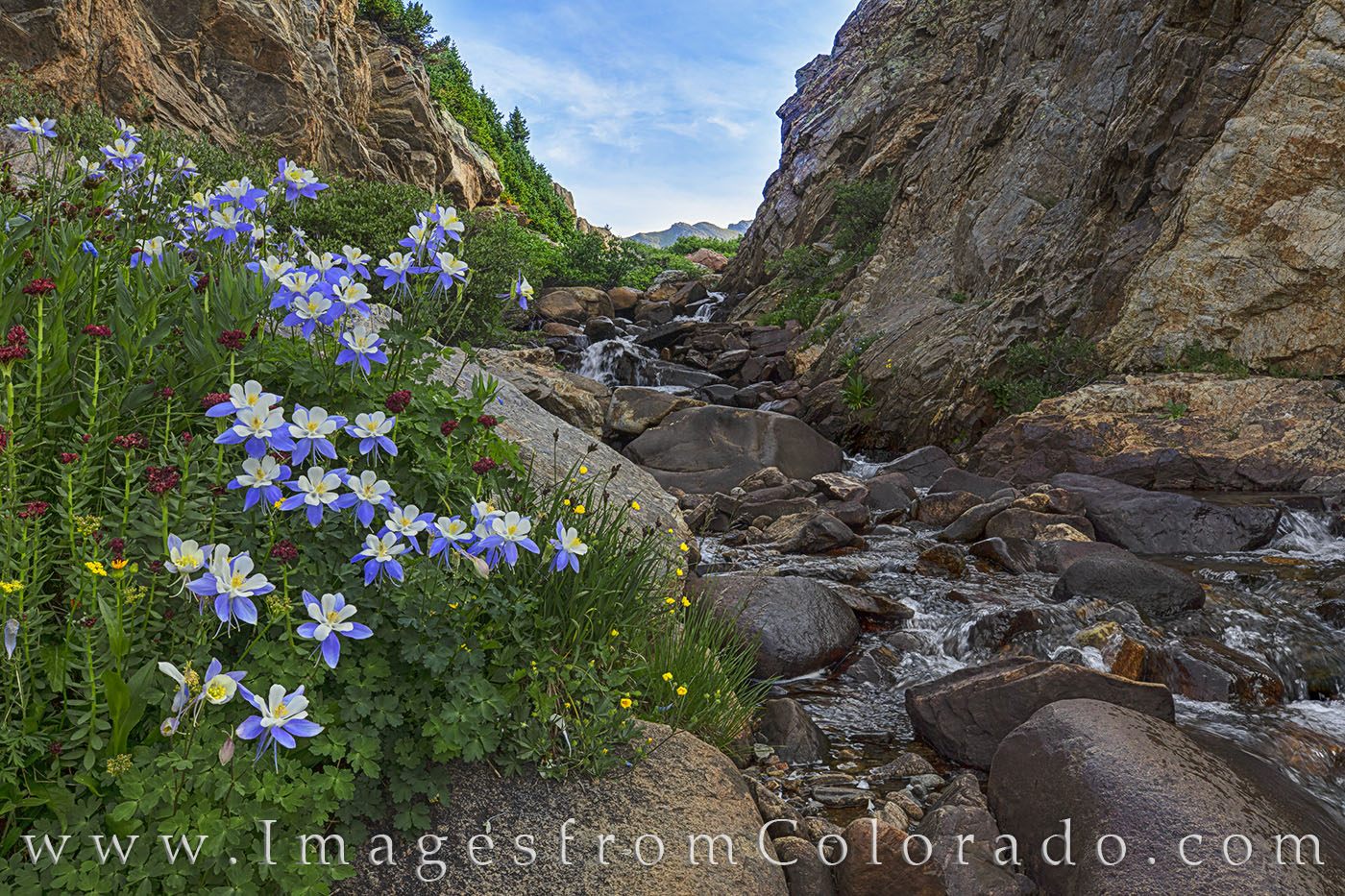
Each summer, I spend some time hunting Colorado Wildflowers. Despite the drought conditions in much of Colorado, some colorful blooms were still out there. Probably my favorite place this year was on a hike to Lost Man Lake near Independence Pass. I had to drop about 10 feet down into a ravine, then cross a very cold stream, but a cluster of Columbine caught my attention and provided a beautiful foreground for a fast-flowing cascade near Aspen, Colorado. Beautiful Columbine, Colorado’s state wildflower, fill in the rocky crags of a small stream flowing down from Independence Pass. This area, while not in the Maroon Bells Wilderness, is a short drive from Aspen on the Lost Man Lake Trail. The July morning was amazing and the flowers were prolific.
Another location with good wildflowers was a hike along the Upper Piney Lake Trail. About five miles up the trail, the last three providing some class three scrambles, a friend of mine and I finally made it into a large cirque. Here, golden sunflower and purple aster flowed down from the steep slopes. Aspen Sunflowers and Purple Asters line a small stream flowing down from the peaks of Summit County. These wildflowers were found about five miles up the Upper Piney Lake Trail outside of Vail in mid July.
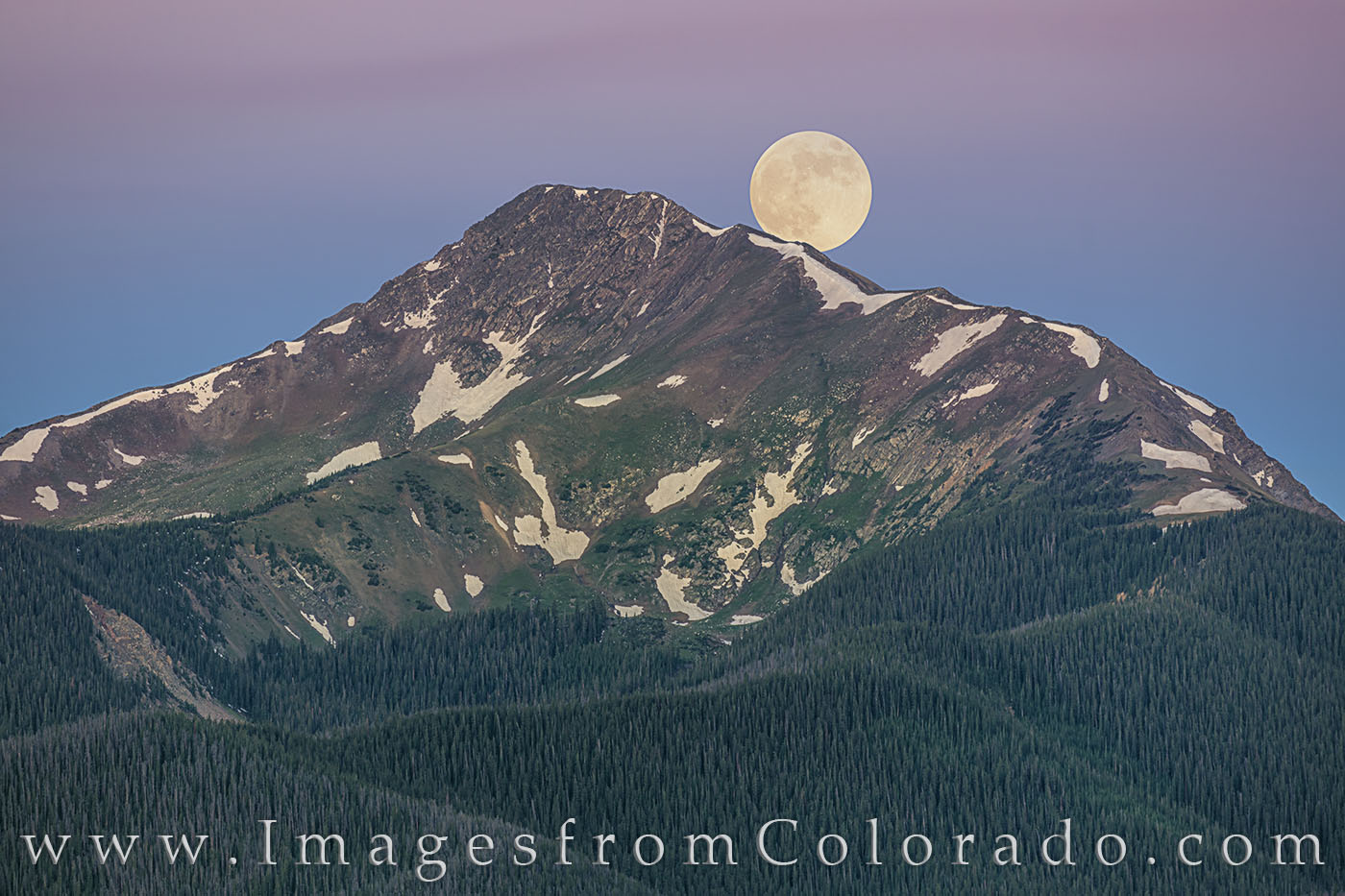
Closer to home, I took advantage of the full moon to photograph a Fraser Valley icon, Byers peak. Taken with a 400mm lens, this long range view shows the full moon setting over Byers Peak near Fraser, Colorado, on a very cold morning. With the temperature at 30 degrees here in Grand County, my fingers were nearly frozen as I waited for the moon to start its descent behind this icon of the Fraser Valley.
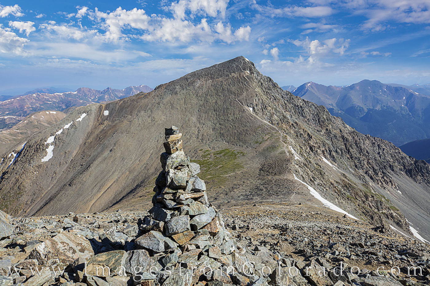
Each summer, a friend of mine and I climb a few mountains. This summer, we hiked up a repeat – Grays and Torreys Peak. We’ve climbed 31 of Colorado’s 54 14,000’ peaks, but summited nothing new this year. Still, here is an image from the top of Grays A cairn marks the path down from Grays Peak (14,270’) to the saddle and back up to Torreys Peak (14,267’). The skies were beautiful and the trail down and back up quite rocky. Still, the views from these 14ers are amazing, and I’m grateful for the opportunity to see the world from up here.
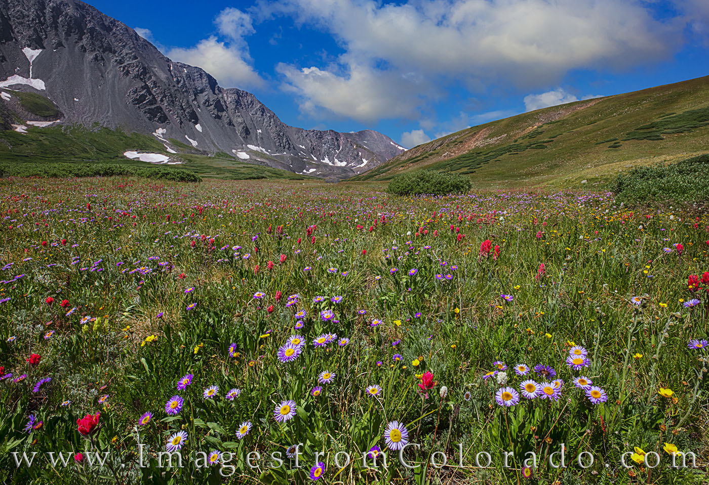
The wildflowers along the trail were pretty amazing, as well. With Grays Peak (14,270’) in the distance, the wildflowers in Stevens Gulch and along the Grays Peak Trail add an explosion of color to a mild summer afternoon. The hike up and back is nearly 8 miles, and the scenery along the way can be breathtaking (and not because of the altitude!). This trail follows the Continental Divide Trail, as well, and leads the way to two of Colorado’s 14,000’ peaks – Grays Peak and Torreys Peak
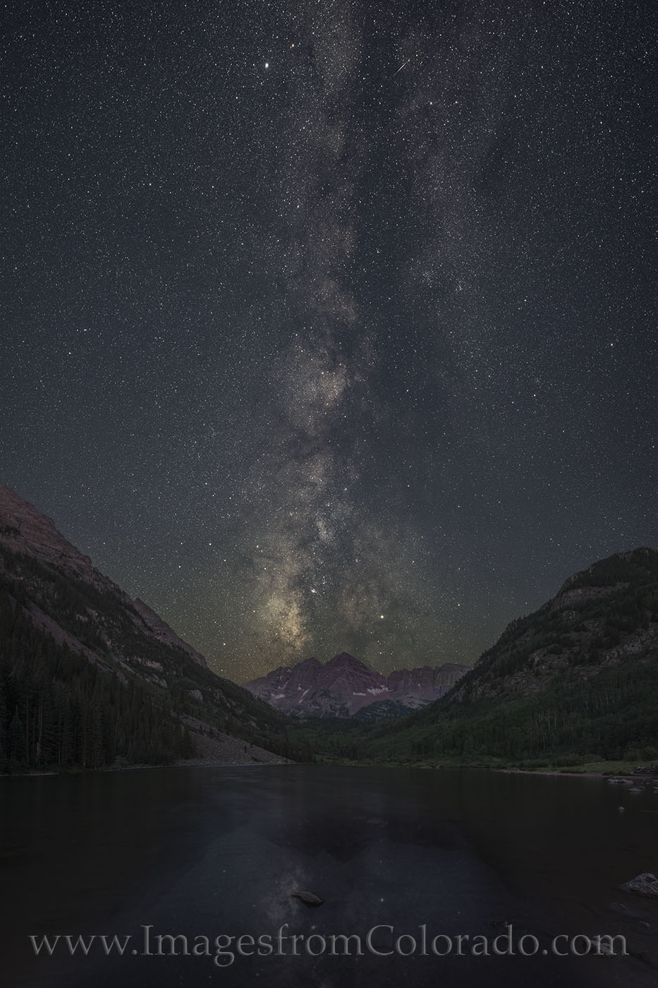
One of my favorite places in all of Colorado to spend time is the Maroon Bells. A lot of other folks feel the same way, as it is the most photographed place in the state. The two peaks, North Maroon and Maroon Peak, both rise over 14,000 feet high. With Maroon Lake in the foreground, the photographic options are seemingly limitless. As a bonus, each June the Milky Way rises over the peaks for a few days between 3:30am-4:00am. The whole scene is beautiful, and the only folks out at that time are making their way along the lake and heading for an ascent of one of the Maroon Bells peaks. On a beautiful very early morning at Maroon Lake, the Milky Way rolls across the sky. In the month of June between 3am-4am, the Milky Way lines up over the iconic Maroon Bells, both over 14,000 feet high. In the foreground, the waters were relatively calm and clear.
One of the most spectacular sunsets I witnessed this summer came from Rocky Mountain National Park. I had driven over to Grand Lake one evening and into the west side of the park. Up the road a ways is an old barn – locally known as the Little Buckaroo Barn. Despite the whimsical name, this barn is part of a homestead from the early 1900s and is on the National Register of Historic Places. The sunset on this particular night was amazing. As part of an old homestead dating back to the early 1900s, this barn, locally known as the Little Buckaroo Barn, is on the National Register of Historic Places. It sits in the Kawuneeche Valley, beneath the Never Summer Mountain Range in Rocky Mountain National Park. This image was taken on an amazing summer evening as the setting sun lit up the sky in a final explosion of color before night settled in.
I still have a week or so until I have to take my girls back to Texas and get them ready for school, but it won’t be long until I can spend more time up here in the fall.
Until then, I hope you enjoyed this escape from the Texas heat!
Big Bend National Park is one of my favorite places in Texas. Just to the west of this region is the oft overlooked little brother – Big Bend Ranch State Park. I’d wanted to explore this largest state park in Texas for quite some time. My first trek to “the other side of nowhere” happened about 8 weeks ago in early February. That brief excursion left me wanting to see more. My wife and I spent some time along FM 170 between Presidio and Lajitas exploring some of the trails there, but I wanted to return and visit the interior. To accomplish this, I needed some things to fall into place. First, my wife was tired of making the long drive to the Big Bend area, so I needed to gain permission from her to head out for a 3 day trip while she took care of the home front. She agreed, mostly, I think, so she could stay home. Next, I had to find a friend who could take time off and who enjoyed exploring because when I’m camping, I’d rather have someone around to share in the discomfort. So I asked a friend of mine to come along. While he goes by a different name, we’ll call him Bob for this story. And on Friday morning we met at 7am at the Whataburger in Fredericksburg (he came from San Antonio and I departed from Dripping Springs) and were on our way.
Bob is a photographer, as well, though he doesn’t practice professionally. However, he does excellent work and knows what he’s doing, is willing to get up at 345am and stay out late to get the best shots, and likes to experience new places. I had been watching the weather for 2 weeks, even though I realize how unreliable a forecast is until you’re in the 48 hour zone. And even then the forecast looked sketchy with regards for sunrises and sunsets being colorful.
Our plan was to drive the interior of Big Bend Ranch State Park (BBRSP), check in at the Sauceda Ranger Station, then set up camp not far from our trailhead destination. Sometimes plans don’t work out even when you think they did. Everything went as accordingly as far as we knew, as we passed through Fort Stockton, Alpine (had lunch at “Come and Take It Barbecue”), then on through Presidio, then down the 27 mile dirt road to the Sauceda Ranch House. The ranger who was on duty, Kirsten, was quite helpful and full of information. Soon, we had claimed La Posta as our campsite, only about 5 miles from the Fresno Canyon Rim trailhead. The remainder of the afternoon was spent photographing some of the local cacti blooms and waiting until sunset (and hoping for good color in the sky).
On a recommendation from Kirsten, the ranger, we drove the very bumpy 4WD Osa Loop to a lofty clearing. “You’ll know it because all the grass will be flat because the cows lay down up there.” And sure enough, after bouncing and rattling up something that resembled a dirt road, we found the place where the cows lay down. The views were ok, too, but not spectacular (maybe I’d been spoiled from Big Bend National Park). As sunset approached, Bob and I found ourselves on this hill that had nice views in both directions. The sky was not offering much hope for color, so we reluctantly made the decision to drive the 4WD high clearance road back to the main dirt road, then back to camp. About 5 miles from the campsite, the sun peeked through the clouds right on the horizon, and we scrambled to capture the moment. We scurried up a small rocky slope and shot for a short time. I had decided to run back to the car to change lenses, but a rock reached out and grabbed my foot, sending me into a headfirst dive. But I saved the camera (that was the fleeting thought as I hit the ground). A quick check showed I had blood oozing out both hands, and elbow, and both legs. The sun was setting quickly, so the blood could wait. As I type, I have wound on both hands and legs from rock-puncture wounds that caused a fair amount of bleeding. Nevertheless, I still recovered in time to enjoy an unexpectedly colorful pink and blue sunset.
From the interior Big Bend Ranch State Park, the sky lights up on a spring evening. Clouds had dominated the entire day, and we’d all but given up on any colors at sunset. Then, as quickly as a ghostly wind, the sky suddenlly lit up in pink and orange for about one minute, then was gone as quietly as the solitude this park offers. With yucca and ocotillo in the foreground, this image was taken west of the Sauceda Ranch house just off the main park road. This sunset was an unexpected surprise.
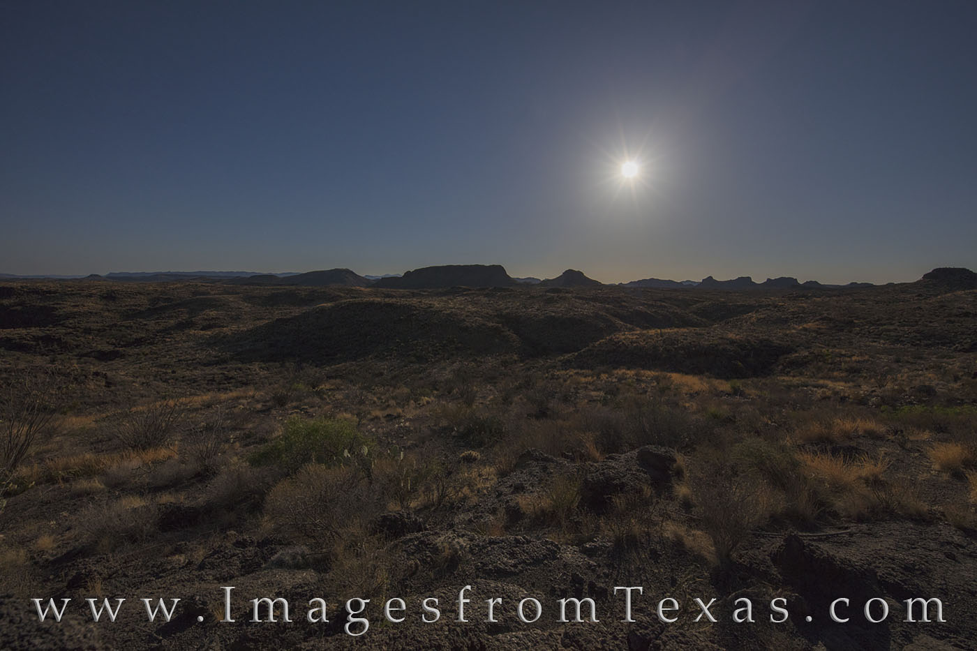
Back at camp, we hunkered down for a rough night. Bob retired to his tent. I chose to stretch out as best as possible in the back of my 4Runner. I feel safe saying it was one of the worst nights of sleep I’ve experienced in quite a while, so it wasn’t that difficult getting ready at 3:45am and driving out by 4am. By 4:20am we had found our trailhead, having only missed one turn. The trail to the rim of Fresno canyon is about 2.6 miles (GPS indicated we covered 2.59 miles) and was well marked – or so we thought. Hiking in the light of a full moon was a pleasure, and we even stopped to shoot the distant mountains as they glowed in the dim light.
While hiking through the desert under the full moon, I decided to stop and use the light the moon to illuminate the landscape of Big Bend Ranch State Park. This area is rugged, and staying on the trail is necessary to avoid becoming lost. This image was taken on the Fresno Rim Trail facing west as the moon began its descent behind the distant mountains.
At one point we even witnessed a meteor streak across the sky. Amazingly, the green trail it left in the night sky glowed for at least 30 seconds. It was a pretty cool thing to see, for sure. Continuing on, we arrived at the canyon rim in a little over an hour – much earlier than we’d planned. How did we get here so quickly? I guess we were fast walkers in great shape. So we waited another 45 minutes until the first glow of orange appeared in the east, then spent the next hour trying to capture those moments of beautiful light at a remote place that few Texans have ever seen – and so many more don’t even know about. It is here that I am embarrassed to say we had not reached the canyon. I admittedly was underwhelmed with the “canyon” that stretched out before us. It was on the smallish side and out of curiosity, I had walked halfway down and back up in the dark. Little did I know at the time, if we had kept going – down and back up – we would have come to an amazing sight. The realization that came a few days later still makes turns my stomach in knots. And my obsessiveness about getting the best shots takes over. And I’ve already started trying to figure out when I can return and take care of this unfinished business.
After all that, we still had a nice sunrise… just not the dramatic views we had expected. But at the time, we didn’t realize our failure, so we were content.
Fresno Canyon cuts through the desert in this remote region of BBRSP, and from our ravine only a quarter mile from the canyon, we got a taste – a partial view – of the Solitario and flatirons. When I visit places like this, I’m always interested in hearing stories about the first settlers. I really can’t imagine attempting to forge out a life in this arid south Texas place. Water is scarce, vegetation is angry and always ready to prick you with tiny spears, and food sources are not abundant. One of the only graces about this harsh environment is that it rests at over 4,000 feet in elevation so the temperatures are often cooler than those along the Rio Grande only miles away.
So with work finished for the morning, we departed. It is always fun to hike in the daylight after the original hike takes place in the dark. The landscape is no longer hidden and mysterious, and the colors, textures, and formations become reality. Everything looks different when you add a little light.
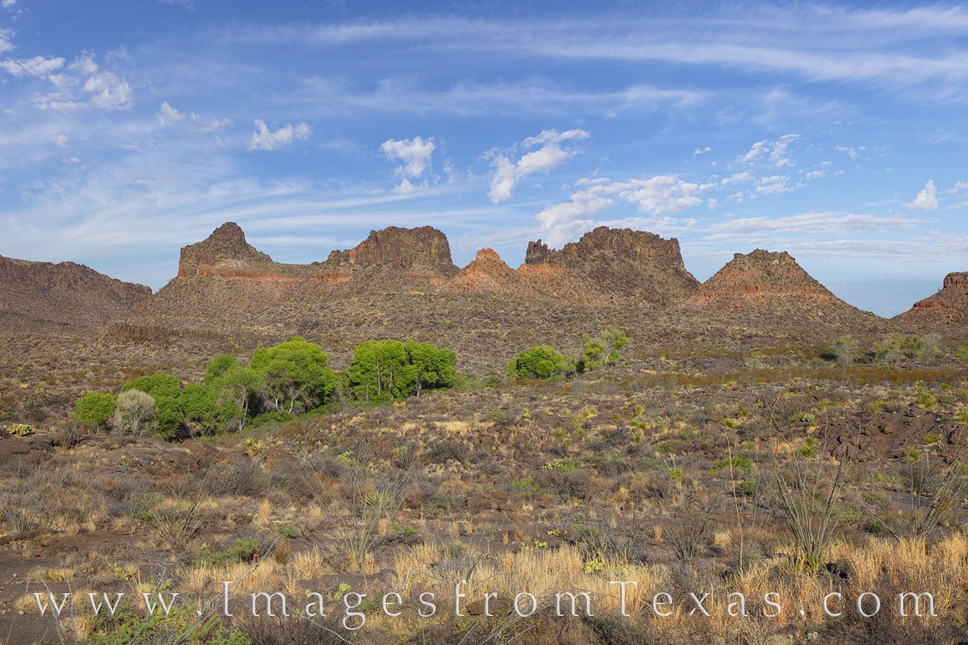
The trail to and from the Frenso Canyon Rim looks a bit different in the day. We had hiked this area in the dark, but on the return trip, the areas where water collected showed off vibrant green in an otherwise dry, rugged, arid desert landscape. The wash where these cottownwood trees thrive leads to an area known as Mexican Falls.
Back at the car, we inched our way back to the main dirt road, stopped to buy a few stuffed animals for my daughters at the ranch house, and took our time to stop and photograph various places on the way back to FM 170.
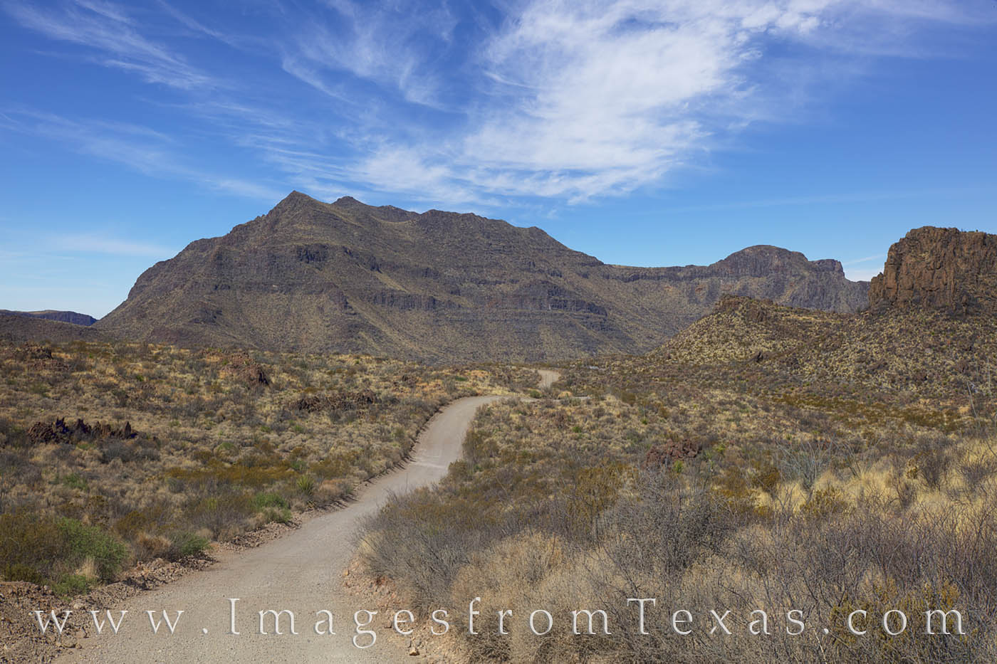
The dirt road that leads to the Sauceda Ranch House rattles on for 27 miles, and further after that. Heading east, after the first 10 or so miles, the views are incredible and filled with interesting rock formations, the Bocifillas Mountains, hoodoos, and more. The vistas over each hill and around each curve make this bumpy ride a surprisingly pleasant experience.
Once our tires hit pavement again (really an underappreciated part of driving), we drove to Presidio, had lunch at the Oasis restaurant (serves a pretty good cheeseburger), then checked into our hotel (the Riata – which despite outward appearance was actually a pretty nice place for cheap – clean rooms and a clean bathroom). For an hour, we rested, then again headed out, this time to photograph probably the most well-known hike in the park, Closed Canyon. I had shot here before, but Bob hadn’t seen it. We met some nice folks from California and Marble Falls along the path, and slowly explored the area between the high rising rock walls that cut through this Colorado Mesa.
Finishing at Closed Canyon, we made the decision to head to our final destination of the evening – the Big Hill. This location appears on some maps, but not others. It is a simple pull-out along FM 170 that offers spectacular views of the Rio Grande looking west. About 100 yards east from this pull-out is another pull-out – this one leading to the Dom Rock. Both of these places are easy access, but if you are willing to put in a bit more effort, even better views can be had.
We knew the full moon would be rising at sunset, so the plan was to shoot both directions and go back and forth – full moon to the east and setting sun to the west. The sunset turned out to be all we could have hoped for – a sky full of pink, red, orange, and blue pastels.
Beneath this colorful palette, the green strip of the Rio Grande wandered west towards the setting sun. More astounding was the fact that we didn’t see another person – or even a car – the entire time we were working. This place really is off the beaten path. I’ll not belabor how beautiful this landscape is, so I’ll just leave this image to show what we experienced.
Big Bend Ranch State Park is an undiscovered treasure. Few folks have visited his year, instead choosing to explore Big Bend National Park just a few miles to the east. But for those who do, the views are incredible and the crowds nonexistent. This image comes from a beautiful Spring sunset from an overlook commonly known as the “Big Hill.” From here, the Rio Grande flows east (towards the camera) as it makes its way onward to Big Bend National Park. On the left (south) is Mexico; on the right (north) is Texas. This evening in BBRSP was just about perfect.
After wrapping up the evening, we made our way back to the hotel (took about 55 minutes), then returned to this spot the next morning for sunrise. Again, colors greeted us with reds and pinks in the sky, but after a colorful sky, eastern clouds soon took over. To the west, the sky was soft blue and white and pink. The contrast in colors between sunrise and sunset always catches my attention, especially when comparing images from relatively the same locations.
From here, the photography part of our trip came to an end, and it was hometime. But not before one more adventure. As we left Terlingua and drove in the direction of Alpine, we made the required stop at Checkpoint Charlie – the area where the border patrol checks cars traveling north. Somehow, their dog make a “hit” on my car, so we were tagged and pulled over. The officers had Bob and I wait in a detention area while they emptied our car. I asked Bob, “Is there anything you want to tell me now?” He said nope, and carried on a lively conversation with the guard who was making sure we didn’t make a run for the… empty, barren landscape that stretched out a hundred miles. We sat there maybe 20-30 minutes while the dog was allowed to sniff around inside our car (all our belongings for the trip had been thrown on the ground). Not surprisingly, the dog found nothing, and avoided the clink. On our way again, made our way through Alpine before stopping at the Dickeys Bbcue in Fort Stockton for an early lunch. After that, it was hometime and hugs for my girls and wife. Yes, it was quite a 3 day tour.
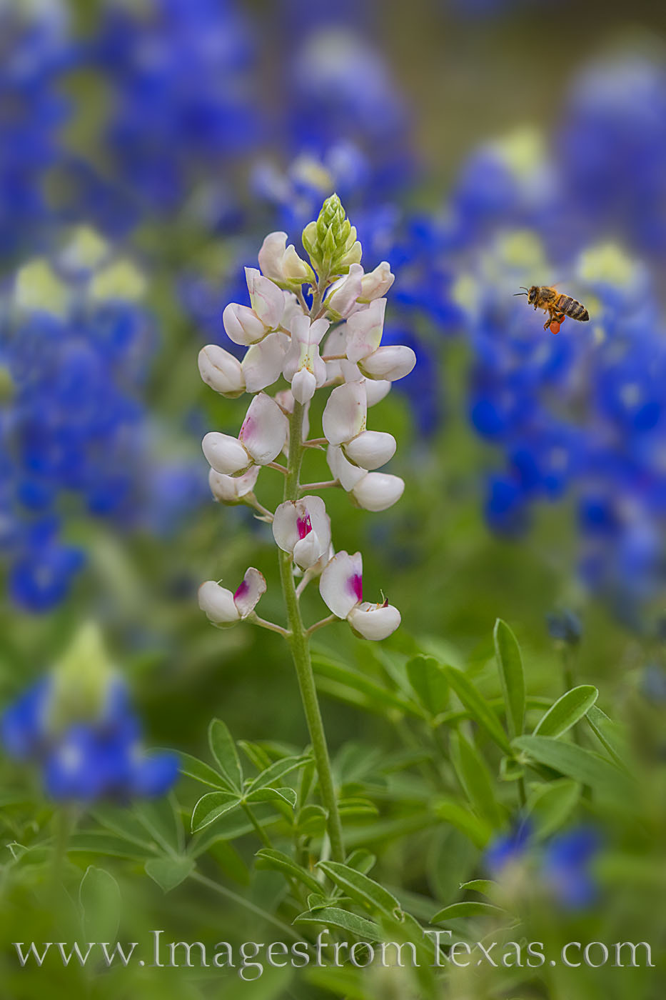
Unfortunately, this has been a less than stellar spring for our favorite Texas wildflower. The reports that I’ve received from friends putting in miles around south and central Texas show that while there are blooms along the roadsides and in some fields, the coverage is not full. I’m still hoping to find a few spots on the hill country for bluebonnets, but I don’t have high hopes. At this point, Ennis might have a decent showing. We should know more in the next few weeks. I’ve taken very few photos of bluebonnets this year, and I think this is my favorite – a white bluebonnet (or whitebonnet): Whitebonnets, Bluebonnets, and a Bee 23 : Prints Available
In a field of bluebonnets, one lone wildflower stood out – this white bluebonnet (or maybe a whitebonnet?). As bees buzzed all around this field, it took 23 shots to capture this image of the bee in flight as it surveyed the unique colors of this single flower in the Texas Hill Country.
It took 23 images to capture this bee in flight. I had originally hoped to photograph a bee that was sitting on a petal, but each time a bee landed, it was on the side of the bluebonnet opposite the lens. But this bee in flight turned out better than I could have hoped.
I do have a good feeling about firewheels. Again, time will tell, and future rains will dictate the fullness of the fields, but I think the Hill Country is off to a good start.
Big Bend is calling my name again. I’m hoping to get out there again before April’s end. I hear the prickly pear cacti are blooming, and I’d like to photograph the Rio Grande at sunset. One morning for sunrise, I am planning on trekking out to Fresno Canyon in Big Bend Ranch State Park. I’ve not spent much time in the interior of BBRSP so I’m looking forward to a little adventure. For some reason, that area (the Big Bend region) appeals to me. I’m not sure if it is the isolation or the big sky landscape, but there is something there – like a distant memory of childhood that brings a peace and joy that really can’t be described adequately to someone else.
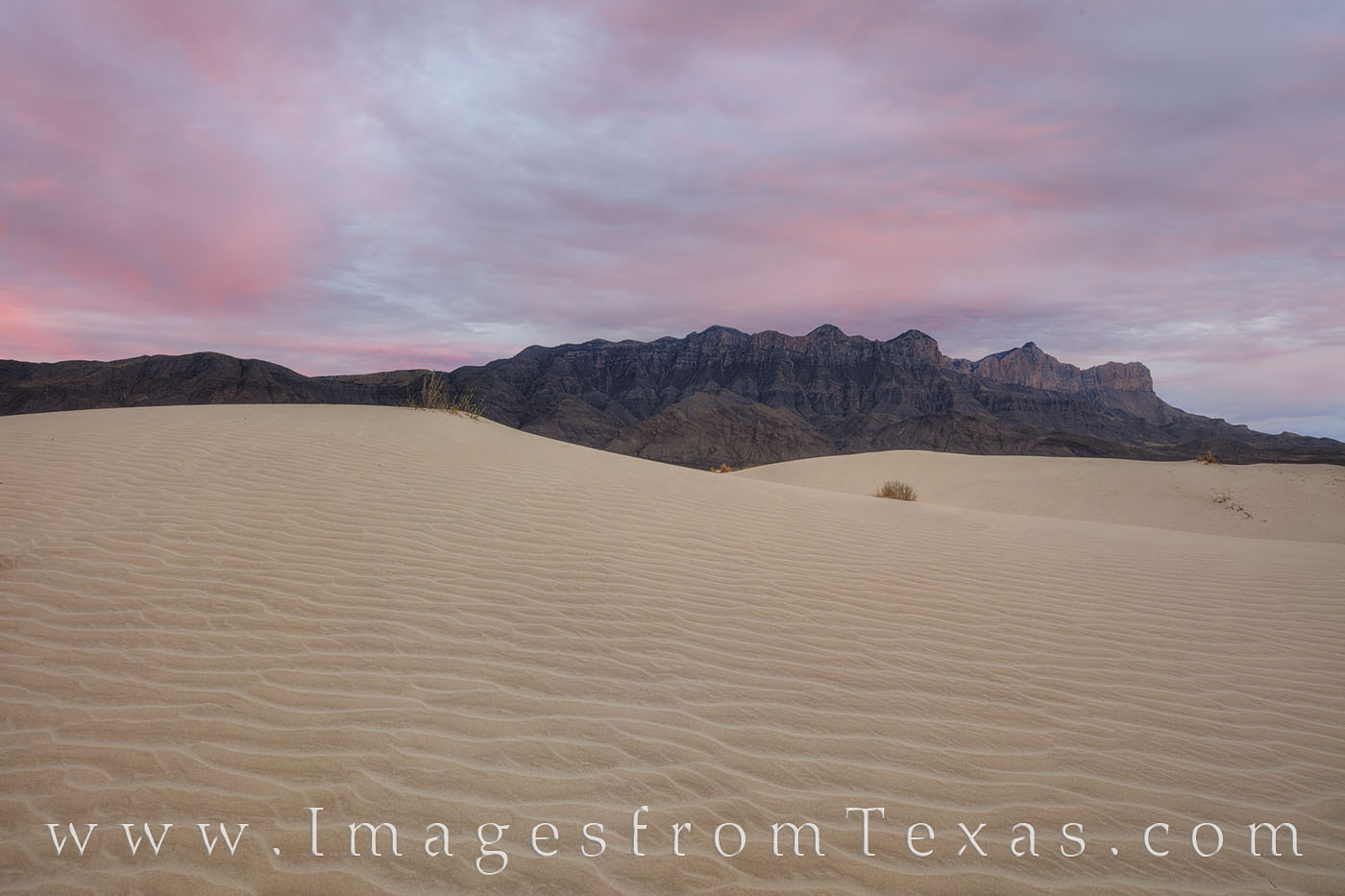
After last week’s trip to the Big Bend area, this week, being spring break for my two girls, found me heading west again, this time with the whole family in tow, to the Guadalupe Mountains. These ancient mountains are a long way from my Texas Hill Country home -~ 8 hours – and if you’ve ever visited the Salt Basin on the southwest side of the park, you know what a remote area it is. After a forty mile drive from Hwy 54 around the south and west sides of the basin, including a 7 mile finish on a white clay road that is impassable when it rains we finally arrived… and saw nary another person en route. After this hour drive off the main road, we still had to cover another mile on foot (according to the park map). However, our total round trip was ~3.5 miles in a trail comprised primarily of very loose sand.
At first the dunes don’t seem like much, but if you head to the right – up and over the steep scrub-filled sand slope -you’ll find a sea of white amazing sand. As you traverse the dunes, avoid any vegetation as this is an ecologically sensitive area.
Like saves of sand, the textures and curves of the salt basin dunes on the southeast side of the Guadalupe Mountains make a stunning foreground for these ancient mountains. In this image, the mountains rise in the spring air as the sun sets in the opposite sky. Guadalupe Peak, the tallest point in Texas, rises 8,751’, and the iconic El Capitan is just south of the summit. To reach these dunes requires a bit of an effort. A 50 mile drive around the park from the Pine Spring Visitor Center, including 7.5 miles on a caliche road that is impassable after a rain, brings you to the trailhead. After that, a dirt and sandy path leads another 1.5 miles to the dunes (the park maps says 1 mile, but it is longer). The round trip hike on this evening was just under 3.5 miles – all worth the amazing scenery in this national park.
After some time exploring the dunes and having the sand all to ourselves, the sun settled in the east behind us and we raced the 1.5 miles back to the car to avoid being locked in the park overnight (the gates are locked 30 minutes after sunset). I’m not sure how strict the park service is on this rule, but I did not want to take a chance on sleeping in the car – in the remote Chihuahuan Desert – with three angry females. We made it out safely, then drove the 2.5 hours to Artesia, New Mexico, for the night.
The next day we drove another 45 minutes hours north and visited the UFO museum in Roswell, New Mexico. Before the museum visit, we had lunch at the Cowboy Cafe. This dive was ranked highly on Yelp and TripAdvisor, bit I’m assuming the competition wasn’t great. Still, little did we realize at the time we should be happy with “average.”
Later, at the International UFO Museum, we enjoyed life sized aliens and plenty of affidavits from important people concerning the reality of aliens and the alleged government coverup. The small presentation was surprisingly well done, and my girls were sufficiently freaked out by the aliens but still had a good time.
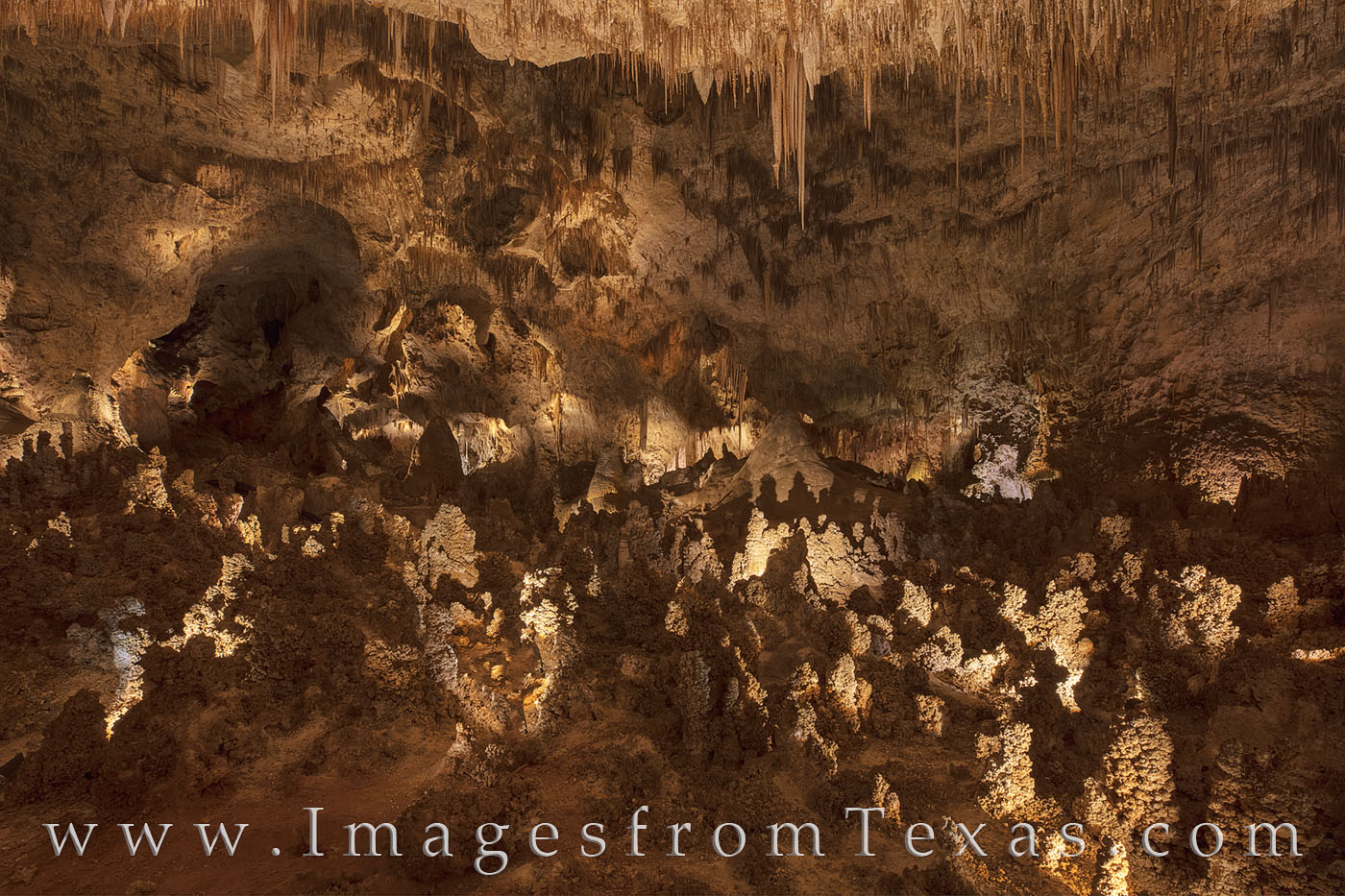
Heading back south and just north of the the Texas border is Carlsbad Caverns, our next stop on the trip. The caverns were amazing and the rock formations nothing like I’ve seen before. We took the self-guided tour that led us through the dark underground and along the 1.25 mile trail and the Big Room. If I was a spelunker or geologist, I imagine I’d have been in heaven. Fairyland in Carlsbad Caverns, New Mexico But I prefer above ground landscapes. As we left, we noticed the large crowds and lines already gathered for entrance. We had arrived early and were glad we did. The crowds were thick as we left, which would have detracted from the quiet spaces of our walk.
Next, we headed south through Van Horn and onto Fort Stockton. First, though, we stopped at a place to eat. Many years ago I watched Chet Garner, host of the DayTripper, eat at Chuys, a Tex-mex joint in Van Horn – NOT affiliated with the well-known Tex-mex chain. I’d wanted to eat here for a while, so we stopped in. I’m sad to say our experience was not good. So be warned… the service was terrible. The guy serving us seemed uninterested in working. Please know we are very low-maintenance. After a 20 minute wait just to take our order, we waited another 30 for the meals. My wife and two girls finally received their food, then the waiter asked if I had ordered the fajitas. Yes… and 20 minutes later my wife and kids had finished their food before mine arrived! But no explanation nor apologies were offered. To top off the experience, the beef was full of fat and very chewy -the worst fajitas I’ve ever had. We paid and got the heck out of there…never again.
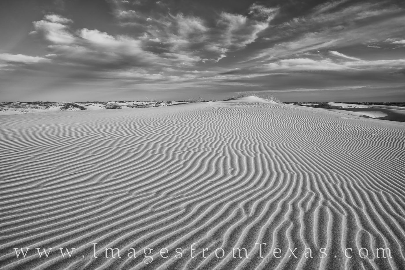
But the sand dunes of Monahans Sandhills State Park awaited, and our mood quickly improved. I’d photographed this small sandy park at sunrise just a week before, but now was returning because I knew my kids would love the sand… and I could shoot at sunset. This image was converted to black and white for the contrast in curves and shadows: Sand Dunes Evening 1 black and white : Prints Available
The lines in the sand at Monahans Sandhills State Park can be mesmorizing. Here in the late afternoon, soft shadows enhance the curves and texture as the winds create ever changing patterns.
We arrived a few hours before dusk, and my girls immediately took off, heading to the tallest dune, then sliding down and laughing the entire time. It was a good way to end our trip – sunset was beautiful, everyone was happy at the same time (which is rare), and laughter filled the still air as we traversed the sand back to the parking lot. It was hometime the next morning, and I always become a bit sentimental when family time ends. I know my kids won’t stay young, and I value each day I have with them.
West Texas called, and when I picked up my girls from school on that Thursday afternoon and my eldest daughter decided she wanted to go with my wife and I, we hurriedly packed her bags while my folks came to watch our youngest. And we were off.
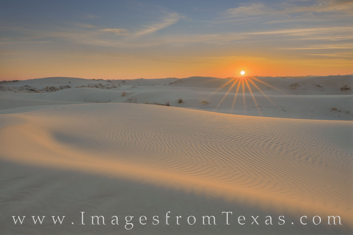
I often feel like Chevy Chase trying to keep the family happy on trips, but this would be a different dynamic with just one kiddo along. I stressed to my oldest that this was a work trip. No whining or complaining about early mornings or late evenings was allowed. So we headed out, and our first stop was Monahans Sandhills State Park, a 3,000+ acre park full of rolling sand dunes. However, this time I’d go alone at sunrise. The dunes were pristine and the sunrise beautiful. I never saw another person that morning as I slipped across the dunes, angling for the best views of sand, sun, and sky. Sunrise at Sandhills State Park 2 : Prints Available
With soft clouds overhead, the sun shows its colors as it rises across Sandhills State Park. The sand dunes in this amazing and unique little park are fun to play on, but they have a special beautiful at sunrise and sunset when all is peaceful and quiet. Close to Monahans, Texas, and right off I-20, this makes a great side-trip if you are in the area.
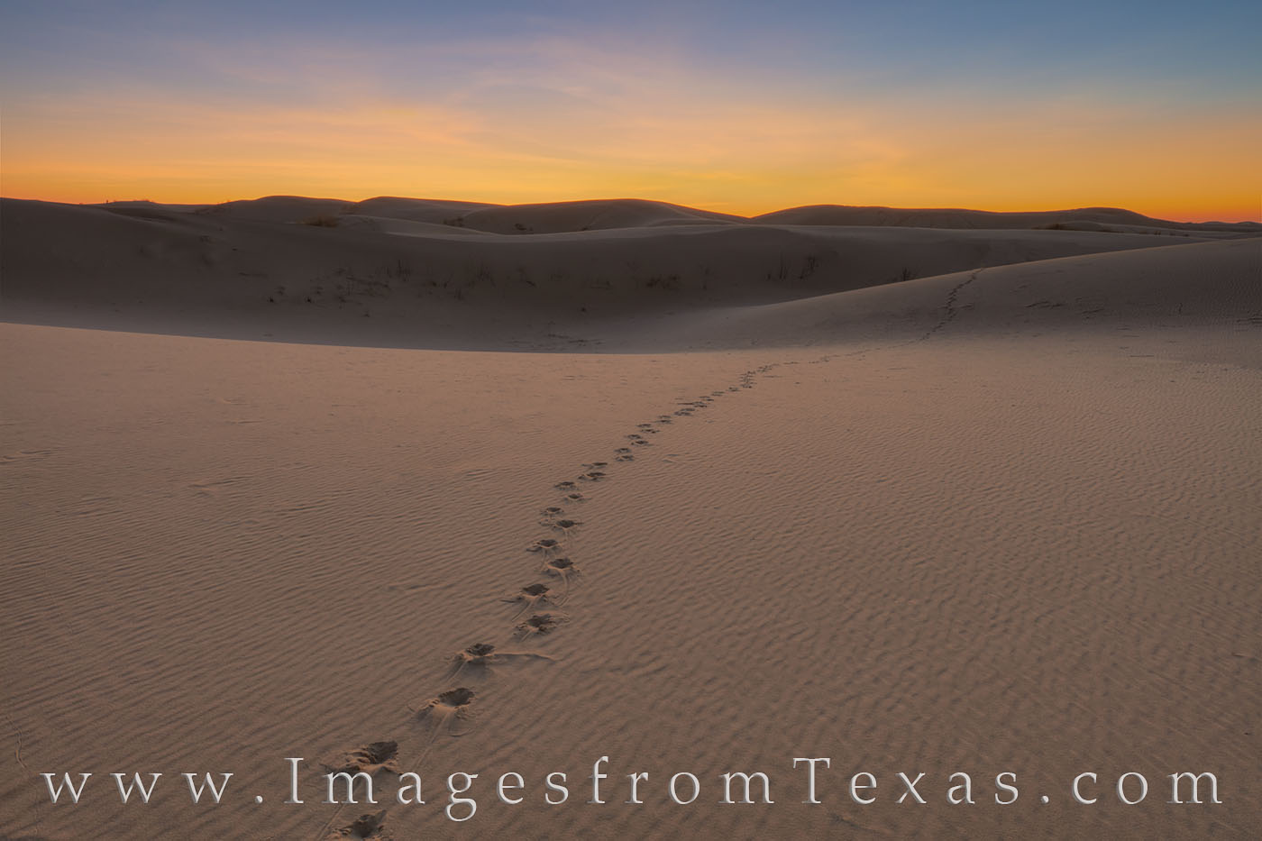
The park is small in comparison to the size of the dunes. The sand stretches on and off for 70 miles. Small critters roam the dunes – rabbits and mice – and bands of Sandhills coyotes keep their numbers regulated. The image below shows the tracks of one of those critters before sunrise. Sandhills State Park Tracks at Sunrise 11 : Prints Available
Tracks across the sand, perhaps from a Sandhills coyote, lead into the eastern sky where sunrise awaits. At times like this when all is quiet and the sun is rising, the land appears beautiful and perfect. The sand dunes in this image come from Sandhills State Park near Monahans, Texas.
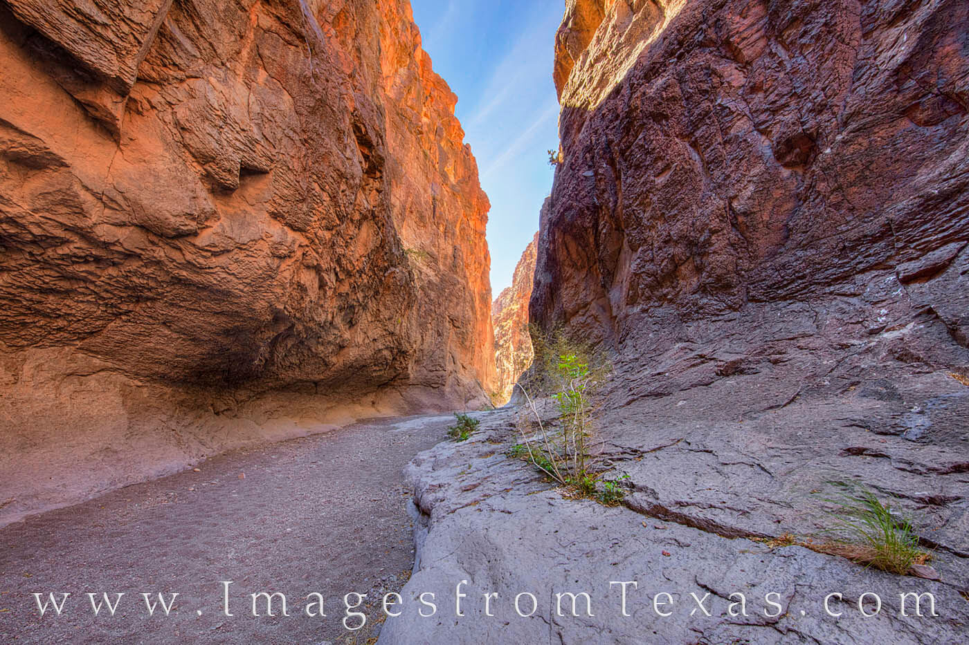
Soon I was heading back to the hotel to pick up my posse and we were off to Big Bend Ranch State Park, the little brother to the national park. We wanted to drive the river road that stretches from Presidio to Lajitas. This area is remote and rugged. We made a few stops along the way – one at the Hoodoo trail and another at Closed Canyon, a small slot Canyon that rises 100 feet above the trail below. After a previous trip to slot canyons in Palo Duro Canyon, it was interesting to see the differences in rock formations and textures between the two canyons. Palo Duro’s canyons we’re smooth sandstone. The slot of Closed Canyon was formed by a stream as it cut through the Santana Tuff of the Colorado Mesa before pouring off into the Rio Grande. Closed Canyon, Big Bend Ranch State Park 2 : Prints Available
Closed Canyon sits just off FM 170 in Big Bend Ranch Stare Park. The hike through this slot canyon is easy, following a sandy and sometimes rocky trail for only .7 miles. High above, the walls of this canyon in the Colorado Mesa have been cut by water into the tuff over millions of years. The sun rarely reaches the canyon floor, and even in the heat of the summer the shade of the canyon offers a respite from the west Texas sun.
Later in the afternoon we had a late lunch at the High Sierra Bar and Grill in the ghost town of Terlingua. A friend had made this recommendation but warned us the staff works at a slower pace. Sure enough, we waited a long time for our food. The waiter, a young guy recently transplanted from Alaska, apologized several times for the slow service,saying they were really busy. A quick look around showed only two of the 8 or so tables taken. One older couple offered to buy drinks for everyone – they were celebrating their first night out after selling their house, buying an RV, and hitting the open road. They were drunk and happy.
The national park was next, and for sunrise I found myself hiking up a small unmarked mesa to shoot the morning light as it backlit the Chisos Mountains directly in front of me. With a few high clouds that quickly dissipated, the morning was nice. For this image I tried to capture the rugged feel of the Chihuahuan Desert floor with the beauty of the mountains in the distance. Chisos Mountains Spring Sunrise 1 : Prints Available
The rugged Chihuahuan Desert stretched across the western slopes of the Chisos Mountains in Big Bend National Park. Taken at sunrise, these mountains rise in the arid desert and contain their unique ecosystem as they reach nearly 8,000′.
Lunch at the Chisos Lodge was followed by an easy hike to Balanced Rock, then back to prepared for the evening adventure.
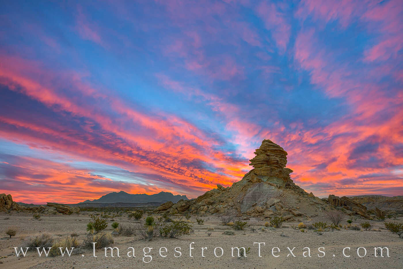
I wanted to go off road again, this time parking along the highway and walking out on the Tornillo Flats to some distant hoodoos. My daughter loved the adventure and rock scrambling that we did. Finding our way across the flat desert to the rock formations was exciting, and the clouds and sun did not let us down. A little after sunset, the sky lit up in reds, oranges, and blues. Hoodoos and the Chisos Mountains at Sunset 1 : Prints Available
The Tornillo Flats rest in the Big Bend National Park area just north of the Chisos Mountains. Off the main road, a short hike across the barren Chihuahuan Desert, several hoodoos and other unique rock formations rise from the sandy floor to create an otherworldly scene. In this image, a hoodoo is seen at sunset with the Chisos Mountains in the distance. Overhead, the sky turns pink, orange, and blue on a beautiful spring sunset.
After taking in the moment with the hoodoos in front of us and the Chisos in the distance, we headed quietly turned and made our way back to the highway. I know times like this are fleeting, and I try to savor the moments.
Next up -a return to west Texas, this time with the whole family.
Looking out the window on this early Sunday morning, I’m seeing fog and drizzle. The weather forecast says to expect the same on and off for the next week. I hope this wet weather bodes well for bluebonnet season. Right now, the spring crop of bluebonnets has the potential to be only average or below. Maybe this rain will boost our chances just a bit for a more colorful spring. I do have a fair amount of bluebonnet rosettes on our land, but from what I’ve heard from other friends who seek out Texas’ favorite wildflower, some of our go-to places are sparse. But you never know with wildflowers… so here’s hoping! In the meantime, I’ve spent some time revisiting old RAW files from 2010, redoing some and even discovering some images I had never finished. I can say 2010 was a really good year for bluebonnets:
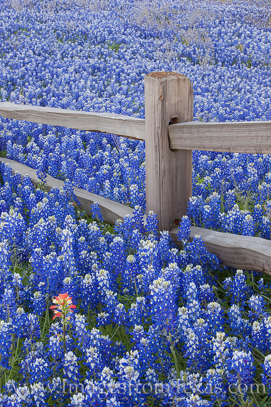
An Indian Paintbrush stands alone in a field of bluebonnets that surround an old wooden fence in the Texas Hill Country. This area in Llano County doesn’t often show this much color, but every 5-7 years during a wet spring, the landscape explodes in a sea of blue with a sprinkling of red.
In a few weeks, I’m heading to Big Bend again… hoping for some bluebonnets out there. I talked to a contact yesterday who works in the park and he said, unfortunately, bluebonnets are not very thick yet, but there could be a few more blooms in the next few weeks. In the Big Bend, bluebonnets tend to bloom from mid-February to mid-March, depending on the weather. Stay tuned on that.
**************
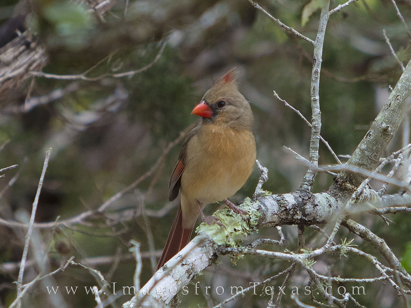
I haven’t taken a landscape photograph, besides shooting the blood moon a few weeks ago, since Thanksgiving. That’s probably the longest I’ve gone in 20 years without doing any photography. I feel it, too. I can tell you (as can my wife and kids) that I’m always happier when I get outside to shoot and explore. And that is why Big Bend is calling my name! In this downtime, I have taken a turn at photographing a few birds on our property. We have bird feeders set up and some beautiful feathered friends, as well as a squirrel and rabbit, visit the feeding area. So I stalked the birds one day and rather enjoyed the quiet time outside. Here is one image of a female Cardinal I came away with, though I don’t see myself becoming a birder anytime soon:
A female Cardinal sits on a limb and watches me watching her.
In February, I had one of my daffodil images used in Texas Highways. I had shot in east Texas near Gladwater on assignment for them last February. It’s always nice to see my work in print.
***************
Last week, in the middle of a gloomy February, I took my wife and two young girls to Disney World in Orlando for 4 days of sun and entertainment. First, I can assure you that the Mouse knows how to take your money. But he knows how to insulate you from the big bad world and show you a good time, as well. One of our new favorite places at the park is Pandora (from the movie Avatar) in the Animal Kingdom. If you are a fan of this sci-fi movie, you’ll love this area. The Avatar – Flight of Passage simulates riding on the back of a banshee and is incredible. Fortunately, we fast-passed this ride and skipped the 3-hour wait. The Na’vi River Journey was beautiful, as well, and full of stunning visual effects. My girls also loved Space Mountain as well as the Frozen rides.
We did have several meals worthy of note, too. First, we enjoyed a buffet in the Animal Kingdom at Boma – a Taste of Africa. In several different areas, there was just about everything you could want for a brunch. I wasn’t hungry for the rest of the day! We also loved another buffet for dinner – this time at our hotel’s restaurant – Cape May. I had three plates of crab legs and shrimp, great clam chowder, tasty desserts, and a good Mai Tai, as well. My girls said the pizza was the best they’d ever had (but they are not great judges on food just yet!) We were sad to see our time end at the Magic Kingdom, but hopefully we can return in a few years when the Star Wars land opens. For now, I have had enough of crowded places to last a while.
I hope yall have a good end-of-February. I look forward to more good news as well as new work to share in the next month.
In the meantime, Vaya con Dios, my friends,
~ Rob Images from Texas www.facebook.com/ImagesfromTexas
First, I have to say it is kind of cool when you visit a national park and one of your books is on display. I had no idea my publisher placed the Texas wildflower book in the Chisos Lodge Visitor Center at Big Bend National Park. I’m humbled and surprised.
My Texas Wildflowers book at the Chisos Lodge Visitor Center in Big Bend National Park.
Next, it looks like we are in the doldrums of winter. Everything is brown and the weather has been generally gray. So on a whim over the holidays I studied and last week took a test that allows me to legally fly a drone for commercial purposes. I owned a drone several years ago but sold it because I did not want to mess with all the legal aspects nor the certification process. On top of that, I don’t want to hear drones overhead when I am hiking or “zenning out”in nature. I do not want to be one of “those guys.” I fully support the banning of drones in state and national parks.
All that said, I’d been asked about obtaining various aerial images of Austin by potential clients over the past year. So, what the heck. I’d read how hard the test was, so a friend and photographer advised me to use the ASA Test Prep study guide. I ended up cramming over about 10 days, then took the test last Thursday. I have to admit that when I started studying, most of the material was foreign – 3D classes of air space on a 2d chart, airport systems, military operations, FAA regulations, etc. However, I finished the test in 37 minutes (you get 2 hours to answer 60 questions.) My proctor told me it was the fastest finish of anyone she’d tested. I figure you know it or you don’t. I made a 93, which means I got 56 out of 60 questions correct. I know one of the questions I just bubbled in the wrong answer. The other three I missed I have no idea what they were asking! Nevertheless, I can legally fly a drone and get paid for it. I suppose one of these days I’ll look into buying a drone ?
That’s about all for now. I hope everyone has a good start to the new year. As for me, I’m looking forward to wildflower season, multiple trips to Big Bend National Park and west Texas, and some summer fun in the Colorado Mountains.