Palo Duro’s Slot Canyons

In my opinion, Texas has one of the most diverse landscapes anywhere in the United States. As my photography business has grown and reached more people across our great state, I’ve had several unique opportunities pop up, and the latest happened this past week – and only reinforced my opinion about the amazing and varied terrain that exists across the Lone Star State.

I was contacted last spring by Todd who runs an incredibly informative blog (with amazing images) called the Caprock Canyoneer. Todd grew up in the Texas panhandle and knows that area and its history better than nearly anyone I’ve met. After months of going back and forth, he arranged for use to meet up with another of his friends, Barry, and explore what they called the Central Utah Slot Canyons – a part of the Llano Slots – located in the remote parts of Palo Duro Canyon.

I rolled into the parking lot before sunrise on the Friday after Thanksgiving – probably around 6:45am. We were supposed to meet up at 7am, and I am never late, especially when afforded an opportunity to shoot in a special location such as this. Not one minute after my arrival, my two new friends pulled up in a black Silverado. They are early, too, and I like that! Having never met in person, I was wondering how we’d work together while covering land without trails. But upon the first handshake and greeting, it was clear these were two genuinely nice and down-to-earth guys. No pretenses; nothing to hide. It was almost as if I’d known them for a long time already.

Back in our cars, I followed them to pullout where we’d leave our cars and begin our hike. Because of the pristine condition of the slots, I cannot divulge the location of our adventure. These slot canyons do not appear on the park map, nor many other maps that I know of for that matter. At one point on our return, Todd and Barry took me by a small canyon closer to the road they called the “Hall of Shame.” This small canyon was filled with graffiti, names carved into stone, and even a monkey face etched into the rock. It was, in a word, deplorable. And it showed why you can’t trust everyone with such natural beauty. I realize that not every person would deface the land, but some will. And I’ve encountered this both in Texas and in Colorado, and it only takes one selfish person to ruin a rock formation that took a million years to form.

After parking along the canyon floor, we readied our gear – cameras, tripods, and lots of water and Gatorade – and began our first challenge – a 600+ foot ascent of the nearest canyon wall. At one point about ¾ of the way up, the clouds turned an amazing pink and blue as the first light of daylight spread across the valley below.

palo duro canyon, texas canyons, texas state parks, exas hiking, hiking texas, texas secrets, texas landscapes, canyon, amarillo, sunrise, texas sunrise, panorama
Palo Duro Canyon Panorama November Morning 1 : Prints Available

Morning light shines across the Palo Duro Canyon area, turning the rock a pink-ish orange and the sky pink and blue hues. Far below, our car sat, and we’d made the first part of our climb to explore the hidden Llano Slot Canyons.

They had warned me there were no trails we’d follow, and they were right. So up we went, hiking the easy parts and scrambling up the more sketchy inclines. But within 45 minutes we were atop the canyon rim, and it seemed all of Palo Duro Canyon spread out beneath our feet. The views were amazing, and through the trees on the canyon’s edge, the first rays of sun filtered through.

palo duro canyon, texas canyons, texas state parks, exas hiking, hiking texas, texas secrets, texas landscapes, canyon, amarillo, sunrise, texas sunrise, canyon rim
Palo Duro Canyon Rim Sunrise 1 : Prints Available

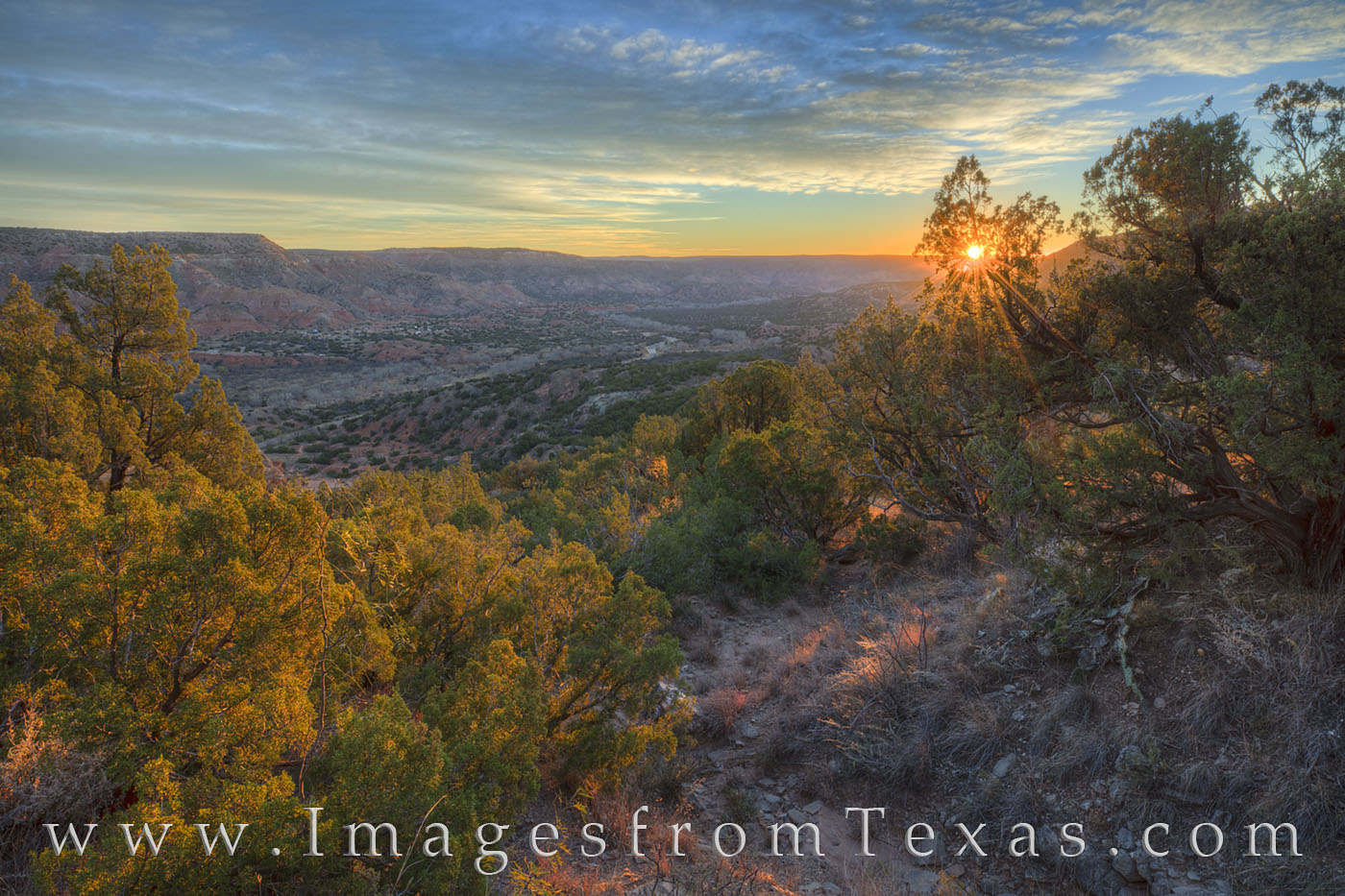
On a hike to Palo Duro’s secret slot canyons, we paused at the top of the canyon rim to take in the cool November sunrise. The valley of this amazing state park stretched out below us, but we had miles to go before the real payoff – the Central Utah Slot Canyons.

And with that, we were off again – heading across a mesa covered in mesquite and tall, dried grasses just high enough to hide the cacti and fallen tree branches and whatever else slithered underneath our feet. Finding my way across this nondescript landscape where everything looked the same in all directions would have been nearly impossible without a GPS or an expert tracker. But still we walked – for many 45 minutes or an hour. I really don’t know as time seemed to stand still and we dodged and weaved our way through the trees and across the grassy land. After more twists and turns, suddenly we stood on the edge of a box canyon.

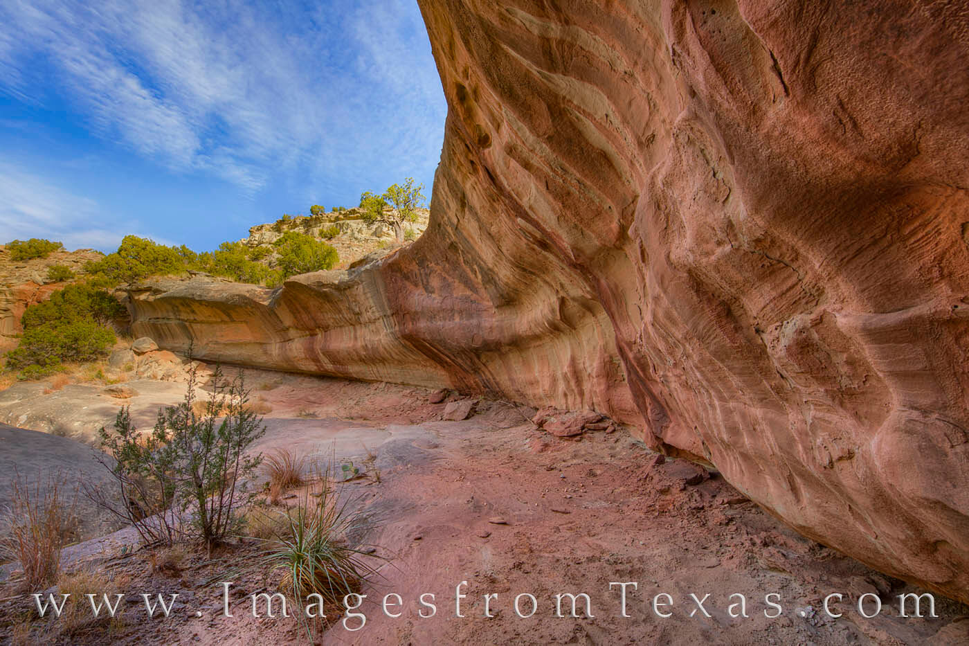
Peering down into this unnamed box canyon, I wondered how we’d descend further, but slowly and methodically, Barry followed a series of natural steps and loose dirt. There were a few slips and skids on the way down, but eventually we made it to the wash and begin following that path for another portion of the trip. Maybe twenty minutes later, we came to a small fissure, an opening in the ground no wider than a few feet. We had arrived at the Central Utah Slot Canyons. The sun was just rising over the nearby rocky ridge, and I peered excitedly into the dark pink and purple rock that waited below.

palo duro canyon, slot canyon, central utah slot canyon, secret canyon, texas canyons, texas state parks, central utah slot, slot canyons, texas slot canyons, texas hiking, hiking texas, texas secrets
Morning at Upper Central Utah Slot Canyon 2 – Palo Duro : Prints Available

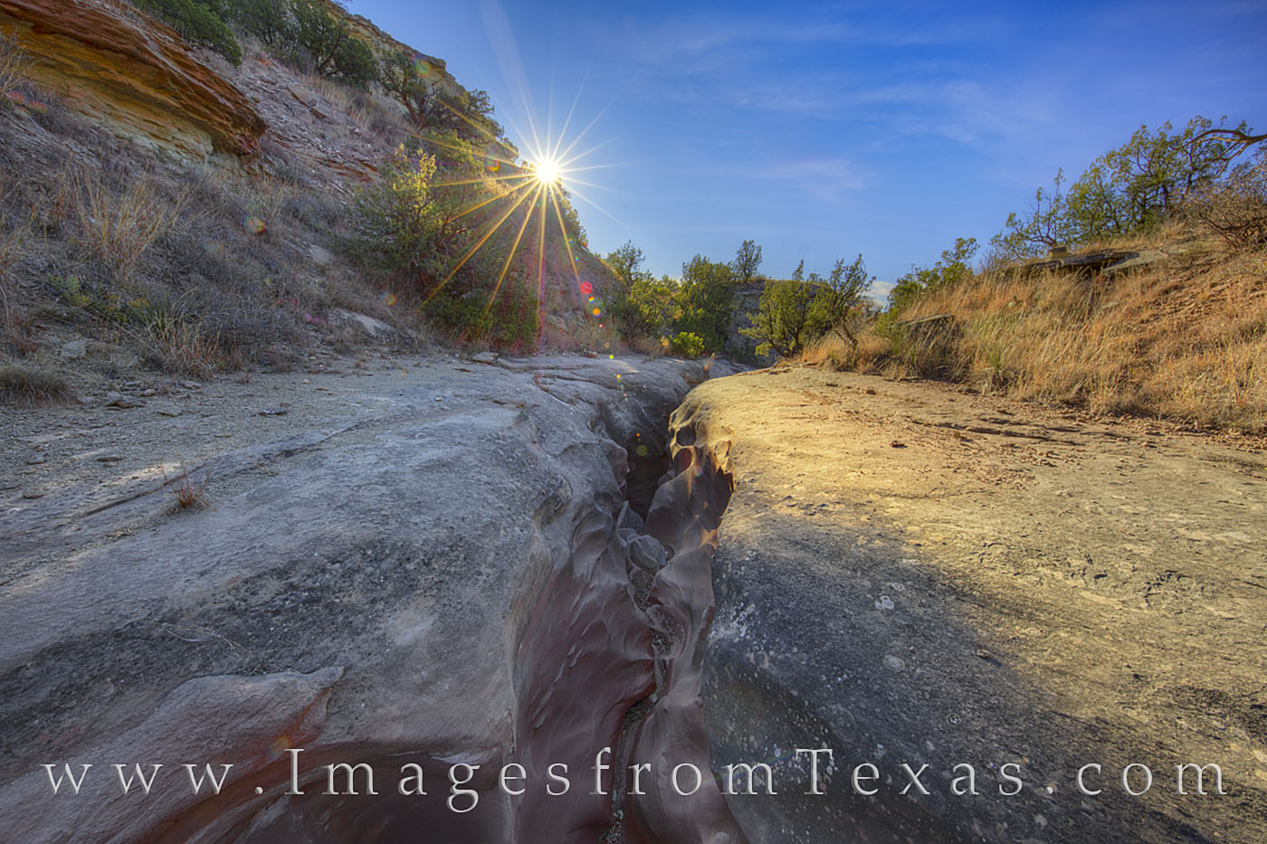
Sunlight streams over the cliff’s edge and we are on the edge of Upper Central Utah Slot Canyon. From a tiny crack in the ground, we made our way down from this point into the most beautiful section of these pristine slots.

palo duro canyon, slot canyon, central utah slot canyon, secret canyon, texas canyons, texas state parks, central utah slot, slot canyons, texas slot canyons, texas hiking, hiking texas, texas secrets
Morning at Upper Central Utah Slot Canyon 3 – Palo Duro : Prints Available

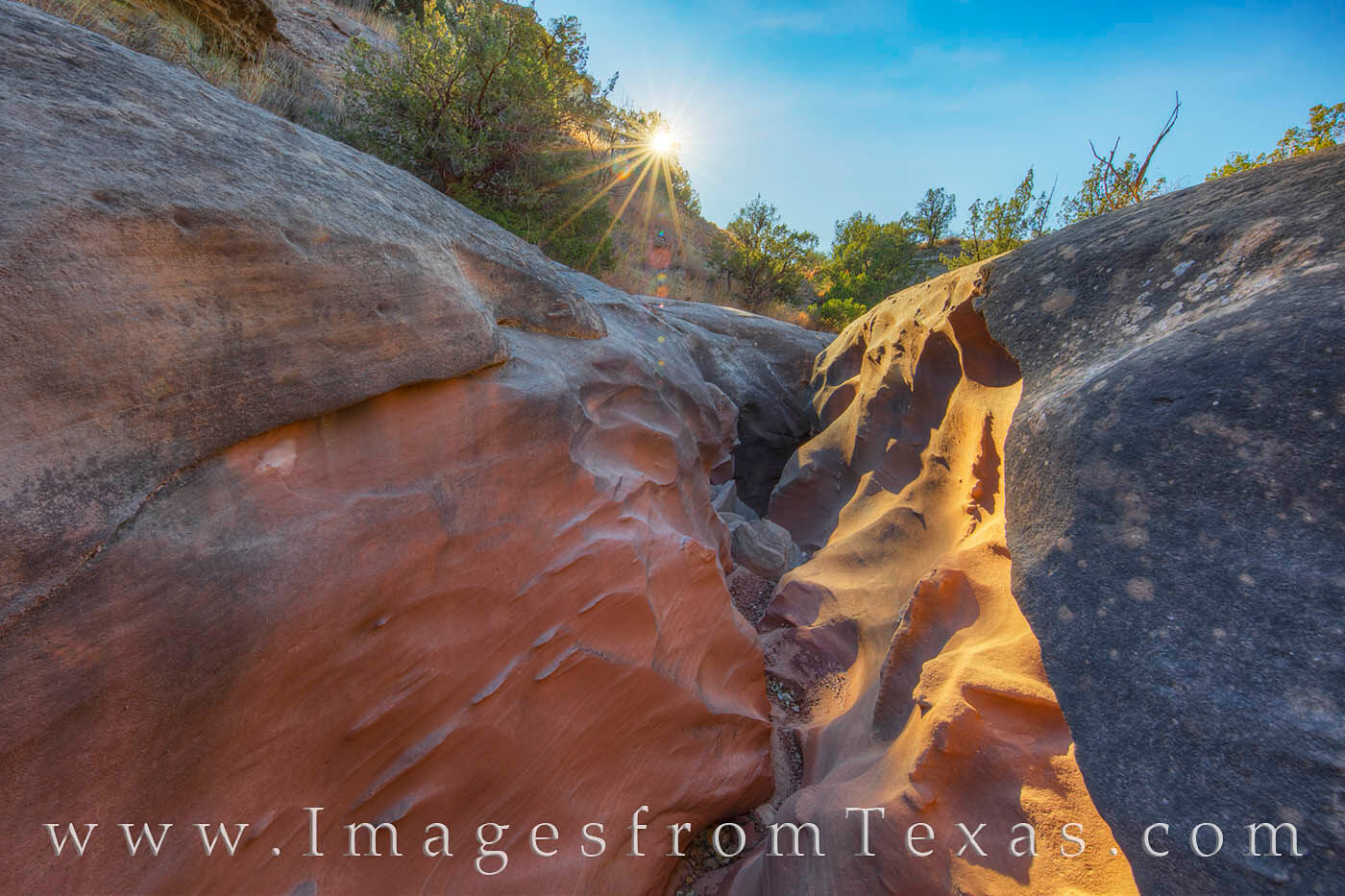
Pink and blue sandstone shows its colors as sunlight begins to fill the beginning section of the Upper Central Utah Slot Canyon in Palo Duro Canyon State Park.

Here, my friends explained, the first slot – the Upper slot – started. It was followed by a Middle Slot and Lower Slot. We’d shoot the first portion as sunlight penetrated the sandstone walls, then work our way down to the Lower slot for best sunlight in that location. Down inside the slots, the color was amazing. The indirect sunlight turned the Trujillo sandstone pink and purple and orange only for a few moments before the direct sunlight disarmed the vibrant and smooth colors. Here, I’ll let the images speak for themselves.

palo duro canyon, slot canyon, central utah slot canyon, secret canyon, texas canyons, texas state parks, central utah slot, slot canyons, texas slot canyons, texas hiking, hiking texas, texas secrets
Llano Slot Canyons – the Upper Slot 3 – Palo Duro : Prints Available

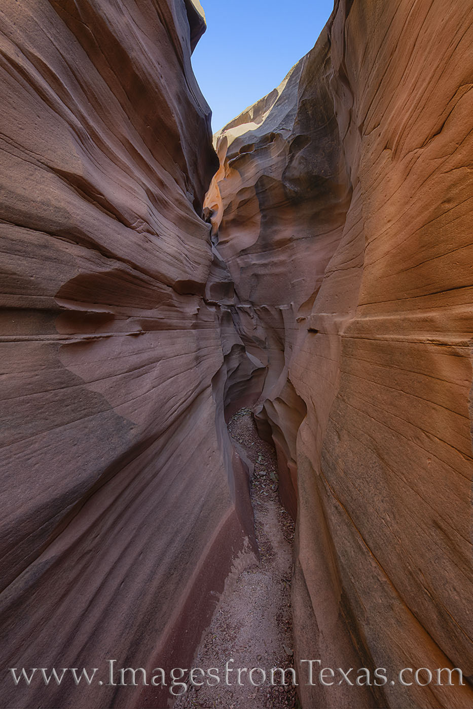
Formed from the rare but repeating rainfalls in the Palo Duro Canyon area, these Llano Estacado slot canyons present a beautiful experience for those fortunate enough to explore them. I was gifted the opportunity by two friends who knew the area well. In this particular slot – known locally as the Upper Central Utah Slot Canyon – the morning sunlight of a cool November day turns the sandstone shades of orange and pink and purple. This area is virtually untouched by humans, and there are no signs of human interference in this pristine portion of the Texas panhandle.

palo duro canyon, slot canyon, central utah slot canyon, secret canyon, texas canyons, texas state parks, central utah slot, slot canyons, texas slot canyons, texas hiking, hiking texas, texas secrets
Llano Slot Canyons – the Upper Slot 2 – Palo Duro : Prints Available

Texas slot canyons are rare and beautiful. While most folks may be familiar with those in Arizona and Utah, they are not aware of these creations in their own Texas backyard. This image shows Central Utah’s Upper Slot Canyon, one of the hidden secrets of Palo Duro Canyon State Park. Formed by infrequent rainfall but rainfall that occurs and causes flooding in the same locations over a long period of time. The sandstone, usually found between 3100 and 3200 feet in elevation, gradually erodes and forms delicate striations and curves. This slot is one of the Llano Slots and resides in the Llano Estacado.
The hike to reach this location covered 9 miles by the time we’d gone out and back, and we were able to explore three different slot canyons. Each slot had its own unique look, and when the morning light of this November day was overhead, the indirect light turned the sandstone walls of the canyon hues of orange and purple.

Then we were onto the Lower Llano Slot Canyon – and one particular curve seemed to glow with warm light just before exploding in direct sunlight.

palo duro canyon, slot canyon, central utah slot canyon, secret canyon, texas canyons, texas state parks, central utah slot, slot canyons, texas slot canyons, texas hiking, hiking texas, texas secrets
Central Utah Lower Slot 3 – Palo Duro : Prints Available

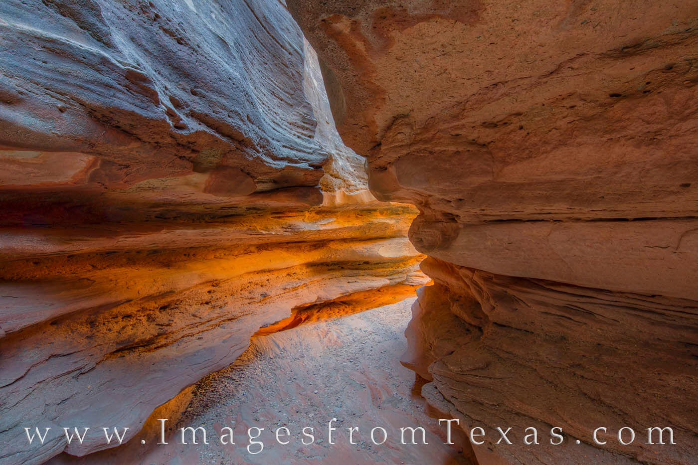
The Central Utah Slot Canyons are located in a remote and seldom seen portion of Palo Duro Canyon. The beautiful rock structures are found in a series of three slot canyons – Upper, Middle, and Lower Slots. This is a view of the Lower Slot Canyon as warm morning sunlight filters in through the sandstone walls. Over the course of an hour, the walls seemed to change from a purple glow to an orange glow as the indirect sunlight progressed through the canyon.

Throughout our work-adventure, Todd explained the history of this amazing place. The pride of his Texas heritage, understanding of historical events, and detailed knowledge of the landscape and its features were captivating, and I only wish I could remember half the information he offered.

I could understand now why they both wanted to keep this place under the radar. We saw now signs of humans – no plastic water bottles, no discarded snack bar wrappers, and no names etched in the wall – something these days that seems quite rare.

palo duro canyon, texas canyons, texas state parks, exas hiking, hiking texas, texas secrets, texas landscapes, canyon, amarillo, sunrise, texas sunrise, canyon rim, slot canyons
The Subway – Palo Duro Canyon : Prints Available

This rock formation – unknown to most visitors to Palo Duro Canyon, and even to many of the park rangers – is called ‘the Subway’ by some of the locals who have visited this location many times. Located just above the Central Utah Slot Canyons in a remote region of the park, this beautiful rock structure has been cut by erosion from wind and rain.

After several hours of exploring and shooting, we decided it was time to begin the journey back. Aside from a few scratches and prickly pear thorns in my shin, the hike back was uneventful – even sliding down the canyon rim to reach the road wasn’t too bad. It was one of those trips I hated to see end. But I hope to return and hike and explore again with my friends. Until then, I’ll enjoy the fact that we live in one of the most beautiful and diverse areas in all of the United States. And for that I’m thankful.

Vaya con Dios, my friends,

Rob
Images from Texas
Follow me on Facebook

Trek to Mariscal Canyon in Big Bend National Park

Standing on the edge of Mariscal Canyon at sunset, the skies colored with pastels of pink and blue, I found myself in the middle of one of my more memorable trips to the Big Bend area. But sometimes the journey is just as important. And the effort to reach the Canyon rim of this grand and rugged landscape made the view that much more satisfying.

Rewind about 24 hours… we had arrived at the Chisos Lodge with a full agenda of locations to photograph at both sunrise and sunset. My wife joined me on this 3 getaway and had agreed to some more, ahem, adventurous hikes if we had a room (as opposed to a tent or back of my 4-Runner). So when an opening at the Chisos Lodge came up, I booked it and plans were made.

We were supposed to arrive in the early afternoon on a Friday after a seven hour drive from our home in the hill country. We arrived later than expected, thanks in part to a mysterious illness that had sapped my strength. Our plans to ascend Emory Peak, the highest point in the National Park, were laid to rest, and I could barely make it around the Window View loop… truly disheartening.

Determined not to let this trip be a failure, I rolled us out of bed the next morning and we drove an hour to Santa Elena Canyon. I’ve shot here several times, but I thought by climbing the few hundred feet of easy switchbacks to shoot sunrise as daylight lit up the Rio Grande valley, it might be a little test for my legs to see how I’d feel for something much more taxing. I should note here that I work out most days and longer hikes of 10+ miles are something I really enjoy.

I made it a half mile and felt about 60% normal, so I was willing to attempt the next part of our plan – and the real reason we drove this far.

Several years prior to this excursion. I’d read trip reports about Mariscal Canyon, a remote rock Canyon 1200 feet above the river. Since then, this had been one of my goals. But timing was important. In the spring, the trail is closed because of peregrine falcon nesting. In the summer months, the temperatures are too hot, staying over 100 degrees most of the day. So here we were, ready to take on this next adventure in early November.

The hike itself is not that difficult on paper, requiring a 1200 feet ascent over 3.5 miles. However, the trail is faint, and in many places marked only by cairns every 20-50 yards. The first 2 miles you gain virtually no vertical feet as the trail crosses several washes, taking you up and down, though mesquite trees, scrub and cacti, and across large areas of nothing. And then you start climbing.

But I am getting ahead of myself. After shooting what turned out to be a rather amazing sunrise at Santa Elena Canyon, we took Old Maverick Road to Terlingua and Far Flung Adventures. From this local establishment, we rented the only available Jeep in town. From all my research, this is literally the only Jeep one could rent – anytime -for at least 100 miles. Kudos to the staff who were friendly and helpful, but I had to laugh when Austin, one of the workers and an experienced hiker, warned that even he would not hike our intended trail at night… just too steep and too much loose rock to be safe. My wife was not pleased.

The Jeep and 4-wheel drive would be necessary for where we were going. My 4-Runner could potentially make it, but I also want my 4-Runner to last several more years. We drove the Jeep back to the Chisos Lodge for an early lunch, bought some gifts for our young daughters, then departed for River Road East around 1:45pm. Turning onto the dirt road after 30 minutes of smooth driving, we began a brutal 90 minute grating and grinding crawl along what I’d call one of the longest sustained %$*#iest roads I’ve ever driven. My wife, who had been been rear ended by stupid/careless drivers several years prior and is sensitive to jerky movements now, held her neck as best she could to mitigate the jarring. I don’t think it helped. My hands hurt from gripping the steering wheel; my back hurt from the constant jarring. And after 30 long miles along River Road East, Black Gap Road, and Talley Road, we arrived at the trailhead.

Mariscal canyon, Mariscal canyon trailhead, jeep, big bend national park, big bend, big bend canyon, hiking texas, rio grande, chihuahuan desert, hiking
Mariscal Canyon Trailhead Sign 1 : Prints Available

After 30 miles of a horrid dirt trail on the south side of the Chisos Mountains in Big Bend National park, our jeep finally brought us to the end of the road – literally. We exited the car to find this trailhead sign awaiting us – and our destination was Mariscal Canyon and the rim that overlooked the deep Rio Grande Valley below.

Opening the Jeep door, we were met with unusually high temps for November – 95 degrees and no shade in sight. I soaked my hat in cold water, started tracking with 2 GPS units, loaded the backpacks with a camera, two lenses, tripod, flashlights, lots of water and Gatorade, and we were off.

The trail starts off by following cairns through a wash of mesquite, then rises 300 yards later on the other side. The first two miles is uneventful, taking you through barren landscape where only tarantulas seemed to live. After one mile and baking in the full force of the sun, we were able to take refuge in the small shadow of a tall yucca. It wasn’t much, but that shade made a huge difference as we guzzled water for a few minutes. We stopped to drink whenever shade presented itself, which wasn’t much.

Mariscal canyon, Mariscal canyon trailhead, jeep, big bend national park, big bend, big bend canyon, hiking texas, rio grande, chihuahuan desert, hiking, Mariscal canyon trail
Mariscal Canyon Trail 1 : Prints Available

Though the trail was lacking, these cairns (lower middle of the image) mark the way leading up to the remote and amazing beautiful Mariscal Canyon in Big Bend National Park. While easy enough to spot during the day, returning in the dark proved more tedious – and a visual challenge. Strong flashlights helped, as did patience. On the way up, we encountered big horn sheep; on the way down a family of javelinas. The reward was one of the most beautiful locations anywhere in Texas.

After two miles, we started the ascent, and the cairns led us up to a flat area about 800 feet above the Rio Grande. Looking back from where we came, we could see the winding green swath the river cut through the dry and scorched Chuhuahuan Desert.

Mariscal trail, Mariscal canyon, rio grande, big bend national park, big bend images, chisos mountains, chihuahuan desert, big bend hikes, hiking big bend, texas hikes, texas adventures
Mariscal Canyon Trail Looking Back 1 : Prints Available

The path from the Mariscal Canyon Rim Trailhead up to the canyon rim really isn’t much of a trail, but a series of rock piles (cairns) that lead across a few miles of the Chihuahuan Desert and up a scrub and cacti-filled slope. Eventually, after trekking over lose rocks and 1200 vertical feet, you’ll reach the amazing vistas the canyon rim offers. As one of Big Bend’s most remote areas, you’ll rarely encounter others, and you’ll have the desert to yourself.

This view comes from about the 3 mile mark. As you make your way towards the canyon rim, turn and round and enjoy the beautiful Rio Grande River valley with the ancient mountains of Mexico in the distance.

This Big Bend panorama is available in larger and custom sizes.

My wife was suffering at this point, and I was worried she was overheating. We paused in the shade of a large rock outcropping, rehydrated, and rested. As for me, I felt fortunate to be in a place like this, and I was getting stronger by the hour, feeling more and more in my comfort zone. Five minutes later we continued upward, covering the final 500 vertical feet over about a third of a mile. The rocks were loose and the trail wandered higher through cacti and sharp rocks. Finally, after plodding for 30 more minutes, we arrived on the plain of the plateau and worked our way to the Canyon rim. Exploring the edge of the abyss, I settled on what was my favorite view of the Canyon walls and Rio Grande far below.

Mariscal Canyon, Big Bend national park, Big bend canyon, canyon, big bend, national park, hiking, hiking texas, texas outdoors, texas national parks, rio grande, mexico, talley, river road east, rive
Mariscal Canyon Afternoon, Big Bend National Park 1 : Prints Available

Mariscal Canyon is one of three deep canyons reside in Big Bend National Park. This rocky and beautiful cliffs form the most remote of the three canyons and only the most hearty adventurers reach this point. The cliffs drop nearly straight down 1200 feet into the Rio Grande. On one side of the river is Texas; the other side is Mexico. After an arduous trek of 4WD roads and cross country hiking to reach the rim of this stunning location, the sight before me was much appreciated on this late afternoon in November.

Mariscal Canyon, Big Bend national park, Big bend canyon, canyon, big bend, national park, panorama, hiking, hiking texas, texas outdoors, texas national parks, rio grande, mexico, talley, river road
Mariscal Canyon Evening, Big Bend 5 : Prints Available

It took 5 hours to arrive at this amazing overlook deep a remote region of Big Bend National Park – a 2+ hour drive across to pretty rough roads and a 3.5 mile hike across a foresaken desert finally brought us to this point – the stunning Marascal Canyon. Below, the Rio Grande cuts through the 1200 foot canyon as it meanders east, dividing Texas and Mexico. Views and lanscapes like this – with not a single person within 2 hours – are what keep me coming back to this national park, both for photography and for escape.

After shooting until nearly dark, we started our descent in the dark, but not before one final shot of an amazing sunset:

Rio Grande, Mariscal Canyon, sunset, Big Bend sunset, Big Bend National Park, texas hikes, texas sunset, hiking texas, mariscal canyon trail
Rio Grande from the Mariscal Trail at Sunset 1 : Prints Available

After spending some time on the rim of Mariscal Canyon, we started the trek back to the jeep. The sky over Mariscal Canyon was already fading, but as we walked east, the setting sun provide one last explosion of light. In the distance, you can even see the orange light reflected in the winding Rio Grande as it divides Texas and Mexico.

Using a powerful flashlight and headlamps, we methodically followed the cairns, picking our way through dark terrain. At one point, we even surprised a family of Javilinas which was a little unnerving. Nearly two hours later we arrived back at the Jeep. Next came that horrid road, then paved road back to Terlingua to drop off the Jeep, pick up my car, then drive back to the Lodge… all in all more than 3 hours of driving before arriving at our room just before midnight.

The next morning, I coerced my wife from her slumber in an attempt to leave early in hopes of finding a good sunrise. On the eastern slope of the park, I was rewarded (and lucky). As my wife slept in the car, the sky above turned orange and purple before we started home:

big bend national park, sunset, texas sunset, ocotillo, texas landscapes, chihuahuan desert, chisos mountains
November Sunrise at Big Bend 2 : Prints Available

Glorious morning light greeted me on this final day of a November excursion to Big Bend National Park. In the foreground, a golden Ocotillo in the Chihuahuan Desert stood still in the cool Autum air and overhead the sky exploded in an array of orange, red, and blue.

If you are ever at Big Bend and have the desire to see one of the most amazing and remote parts of Texas, I highly recommend Mariscal Canyon. Otherwise, I hope you can enjoy the images I captured that memorable evening in early November.

Vaya con Dios, my friends,

Rob

Images from Texas
Follow My Photography on Facebook